Svyatogorsk geodata
Svyatogorsk (Donetsk) is a populated place; located in Ukraine in Europe/Kiev (GMT+3) time zone. With population of 4,900 people, there are 665 cities with bigger population in this country. Compared to other cities in Ukraine, 67.1% of cities are located further ↓South; 92.9% of cities are located further ←West and 73.5% of cities have higher elevation than Svyatogorsk. Note1


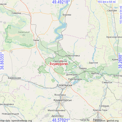
Svyatogorsk GPS coordinates[2]
49° 1' 59.988" North, 37° 34' 0.012" East
| Map corner | latitude | longitude |
|---|---|---|
| Upper-left | 49.49218°, | 36.86355° |
| Center: | 49.03333°, | 37.56667° |
| Lower-right: | 48.57021°, | 38.2698° |
| Map W x H: | 102.5×102.5 km | = 63.7×63.7mi |
| max Lat: | 52.18903° ⇑32.9% North |
| Svyatogorsk: | 49.03333° |
| min Lat: | ⇓67.1% South 44.39214° |
| min Long | Svyatogorsk | max Long |
| 22.20555° | 37.56667° | 40.13222° |
| W 92.9%⇐ | ⇒7.1% E |
Elevation
Elevation of Svyatogorsk is 66 m = 217 ft, and this is 89.8 m = 295 ft below average elevation for this country.
| Max E: |
886 m = 2907 ft | 73.5% |
| Avg. | 155.8 m = 511 ft | |
| Svyatogorsk | 66 m = 217 ft | |
Min E: |
-3 m = -10 ft | 26.5% |
See also: Ukraine elevation on elevation.city.
Geographical zone
Svyatogorsk is located in North temperate zone (between Tropic of Cancer and the Arctic Circle). Distance of this North polar circle is 1949.2 km =1211.2 mi to North.| Distance of | km | miles | from Svyatogorsk |
|---|---|---|---|
| North Pole | 4555.1 | 2830.4 | to North |
| Arctic Circle | 1949.2 | 1211.2 | to North |
| Tropic Cancer | 2846.1 | 1768.5 | to South |
| Equator | 5452 | 3387.7 | to South |


Nearby cities:
15 places around Svyatogorsk: (largest is in red/bold)
• Borova
38.5 km =23.9 mi,  5°
5°
• Chervonyy Oskil
19.2 km =11.9 mi,  327°
327°
• Drobysheve
11.9 km =7.4 mi,  85°
85°
• Izyum
30.3 km =18.8 mi,  310°
310°
• Kramators’k
34.5 km =21.4 mi,  181°
181°
• Krasnotorka
39.1 km =24.3 mi, 183°
• Kryva Luka
30.3 km =18.8 mi,  125°
125°
• Lyman
17.9 km =11.1 mi,  106°
106°
• Novoselivka
10.2 km =6.3 mi,  66°
66°
• Sloviansk
18.9 km =11.7 mi,  168°
168°
• Studenok
8.7 km =5.4 mi,  317°
317°
• Terny
29.5 km =18.3 mi,  77°
77°
• Yampil’
30.4 km =18.9 mi, 110°
• Yats’kivka
16.6 km =10.3 mi,  349°
349°
• Zarichne
26.6 km =16.5 mi, 92°
Sources, notices
• [Note1] Compared only with cities in Ukraine existing in our database
• [Src1] Map data: © OpenStreetMap contributors (CC-BY-SA)
• [Src2] Other city data from geonames.org with taken over terms of usage.
• [Src3] Geographical zone / Annual Mean Temperature by Robert A. Rohde @ Wikipedia
