Inkerman geodata
Inkerman (Sevastopol City) is a seat of a third-order administrative division; located in Ukraine in Europe/Simferopol (GMT+3) time zone. With population of 10,204 people, there are 353 cities with bigger population in this country. Compared to other cities in Ukraine, 97.8% of cities are located further ↑North; 53.5% of cities are located further ←West and 90.1% of cities have higher elevation than Inkerman. Note1
Administrative division(s):
- Level 1: Sevastopol City
- Level 2: Balaklava District
- Level 3: Gorod Inkerman


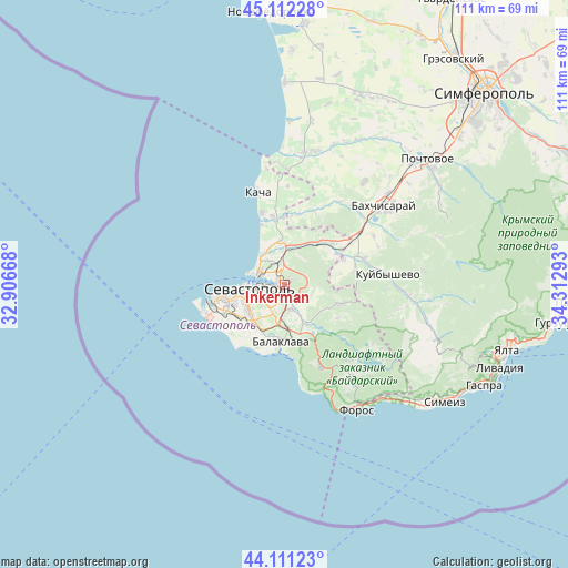
Inkerman GPS coordinates[2]
44° 36' 50.076" North, 33° 36' 35.28" East
| Map corner | latitude | longitude |
|---|---|---|
| Upper-left | 45.11228°, | 32.90668° |
| Center: | 44.61391°, | 33.6098° |
| Lower-right: | 44.11123°, | 34.31293° |
| Map W x H: | 111.3×111.3 km | = 69.2×69.2mi |
| max Lat: | 52.18903° ⇑97.8% North |
| Inkerman: | 44.61391° |
| min Lat: | ⇓2.2% South 44.39214° |
| min Long | Inkerman | max Long |
| 22.20555° | 33.6098° | 40.13222° |
| W 53.5%⇐ | ⇒46.5% E |
Elevation
Elevation of Inkerman is 19 m = 62 ft, and this is 136.8 m = 449 ft below average elevation for this country.
| Max E: |
886 m = 2907 ft | 90.1% |
| Avg. | 155.8 m = 511 ft | |
| Inkerman | 19 m = 62 ft | |
Min E: |
-3 m = -10 ft | 9.9% |
See also: Ukraine elevation on elevation.city.
Geographical zone
Inkerman is located in North temperate zone (between Tropic of Cancer and the Arctic Circle). Distance of this Northern Tropic circle is 2354.7 km =1463.1 mi to South.| Distance of | km | miles | from Inkerman |
|---|---|---|---|
| North Pole | 5046.5 | 3135.7 | to North |
| Arctic Circle | 2440.6 | 1516.5 | to North |
| Tropic Cancer | 2354.7 | 1463.1 | to South |
| Equator | 4960.6 | 3082.4 | to South |


Nearby cities:
15 places around Inkerman: (largest is in red/bold)
• Balaklava
11.5 km =7.1 mi,  184°
184°
• Frontovoye
11.8 km =7.3 mi,  59°
59°
• Fruktovoye
7.4 km =4.6 mi,  355°
355°
• Khmel’nitskoye
8.4 km =5.2 mi,  155°
155°
• Kholmovka
12.5 km =7.8 mi,  66°
66°
• Orlovka
13 km =8.1 mi,  350°
350°
• Pervomayskoye
8.4 km =5.2 mi, 175°
• Rodnoye
12.2 km =7.6 mi,  123°
123°
• Sakharnaya Golovka
4.3 km =2.7 mi,  141°
141°
• Sevastopol
7.5 km =4.7 mi,  248°
248°
• Shturmovoye
5.2 km =3.2 mi,  168°
168°
• Ternovka
11.8 km =7.3 mi,  109°
109°
• Verkhnesadovoye
11.1 km =6.9 mi,  41°
41°
• Vishnyovoye
13.2 km =8.2 mi, 358°
• Zolotaya Balka (1 otd.)
9.1 km =5.7 mi,  187°
187°
Sources, notices
• [Note1] Compared only with cities in Ukraine existing in our database
• [Src1] Map data: © OpenStreetMap contributors (CC-BY-SA)
• [Src2] Other city data from geonames.org with taken over terms of usage.
• [Src3] Geographical zone / Annual Mean Temperature by Robert A. Rohde @ Wikipedia
