Sakharnaya Golovka geodata
Sakharnaya Golovka (Sevastopol City) is a populated place; located in Ukraine in Europe/Simferopol (GMT+3) time zone. With population of 4,146 people, there are 745 cities with bigger population in this country. Compared to other cities in Ukraine, 98.2% of cities are located further ↑North; 54.5% of cities are located further ←West and 79.8% of cities have higher elevation than Sakharnaya Golovka. Note1
Administrative division(s):
- Level 1: Sevastopol City
- Level 2: Balaklava District
- Level 3: Balaklavskiy munitsipal'niy okrug


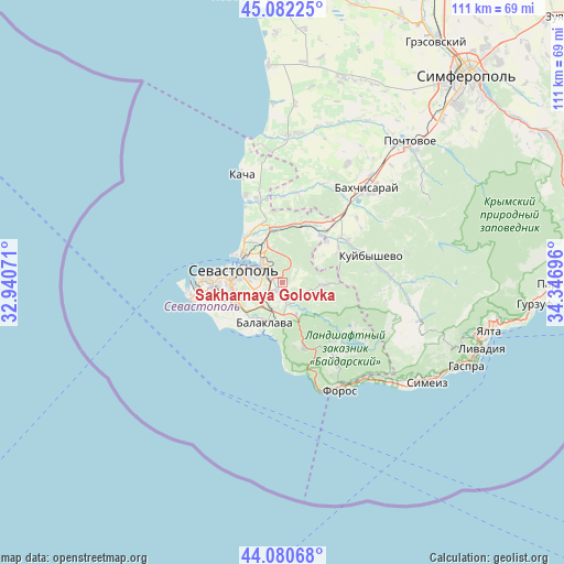
Sakharnaya Golovka GPS coordinates[2]
44° 35' 1.032" North, 33° 38' 37.788" East
| Map corner | latitude | longitude |
|---|---|---|
| Upper-left | 45.08225°, | 32.94071° |
| Center: | 44.58362°, | 33.64383° |
| Lower-right: | 44.08068°, | 34.34696° |
| Map W x H: | 111.4×111.4 km | = 69.2×69.2mi |
| max Lat: | 52.18903° ⇑98.2% North |
| Sakharnaya Golovka: | 44.58362° |
| min Lat: | ⇓1.8% South 44.39214° |
| min Long | Sakharnaya Golo | max Long |
| 22.20555° | 33.64383° | 40.13222° |
| W 54.5%⇐ | ⇒45.5% E |
Elevation
Elevation of Sakharnaya Golovka is 44 m = 144 ft, and this is 111.8 m = 367 ft below average elevation for this country.
| Max E: |
886 m = 2907 ft | 79.8% |
| Avg. | 155.8 m = 511 ft | |
| Sakharnaya Golovka | 44 m = 144 ft | |
Min E: |
-3 m = -10 ft | 20.2% |
See also: Ukraine elevation on elevation.city.
Geographical zone
Sakharnaya Golovka is located in North temperate zone (between Tropic of Cancer and the Arctic Circle). Distance of this Northern Tropic circle is 2351.3 km =1461 mi to South.| Distance of | km | miles | from Sakharnaya Golovka |
|---|---|---|---|
| North Pole | 5049.8 | 3137.8 | to North |
| Arctic Circle | 2443.9 | 1518.6 | to North |
| Tropic Cancer | 2351.3 | 1461 | to South |
| Equator | 4957.2 | 3080.3 | to South |


Nearby cities:
15 places around Sakharnaya Golovka: (largest is in red/bold)
• Balaklava
8.8 km =5.5 mi,  203°
203°
• Frontovoye
11.9 km =7.4 mi,  38°
38°
• Fruktovoye
11.2 km =7 mi,  342°
342°
• Goncharnoye
13.8 km =8.6 mi,  161°
161°
• Inkerman
4.3 km =2.7 mi,  321°
321°
• Khmel’nitskoye
4.4 km =2.7 mi,  169°
169°
• Kholmovka
12.1 km =7.5 mi,  46°
46°
• Krasnyi Mak
12.7 km =7.9 mi,  59°
59°
• Pervomayskoye
5.3 km =3.3 mi, 201°
• Rodnoye
8.2 km =5.1 mi,  113°
113°
• Sevastopol
9.6 km =6 mi,  273°
273°
• Shturmovoye
2.5 km =1.6 mi,  223°
223°
• Ternovka
8.5 km =5.3 mi,  93°
93°
• Verkhnesadovoye
12.6 km =7.8 mi,  21°
21°
• Zolotaya Balka (1 otd.)
6.9 km =4.3 mi,  214°
214°
Sources, notices
• [Note1] Compared only with cities in Ukraine existing in our database
• [Src1] Map data: © OpenStreetMap contributors (CC-BY-SA)
• [Src2] Other city data from geonames.org with taken over terms of usage.
• [Src3] Geographical zone / Annual Mean Temperature by Robert A. Rohde @ Wikipedia
