Surs’ko-Mykhaylivka geodata
Surs’ko-Mykhaylivka (Dnipropetrovsk) is a populated place; located in Ukraine in Europe/Kiev (GMT+3) time zone. With population of 2,552 people, there are 1023 cities with bigger population in this country. Compared to other cities in Ukraine, 50.5% of cities are located further ↑North; 76.8% of cities are located further ←West and 73.8% of cities have higher elevation than Surs’ko-Mykhaylivka. Note1


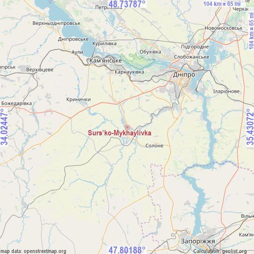
Surs’ko-Mykhaylivka GPS coordinates[2]
48° 16' 19.272" North, 34° 43' 39.324" East
| Map corner | latitude | longitude |
|---|---|---|
| Upper-left | 48.73787°, | 34.02447° |
| Center: | 48.27202°, | 34.72759° |
| Lower-right: | 47.80188°, | 35.43072° |
| Map W x H: | 104.1×104.1 km | = 64.7×64.7mi |
| max Lat: | 52.18903° ⇑50.5% North |
| Surs’ko-Mykhaylivka: | 48.27202° |
| min Lat: | ⇓49.5% South 44.39214° |
| min Long | Surs’ko-Mykha | max Long |
| 22.20555° | 34.72759° | 40.13222° |
| W 76.8%⇐ | ⇒23.2% E |
Elevation
Elevation of Surs’ko-Mykhaylivka is 65 m = 213 ft, and this is 90.8 m = 298 ft below average elevation for this country.
| Max E: |
886 m = 2907 ft | 73.8% |
| Avg. | 155.8 m = 511 ft | |
| Surs’ko-Mykhaylivka | 65 m = 213 ft | |
Min E: |
-3 m = -10 ft | 26.2% |
See also: Ukraine elevation on elevation.city.
Geographical zone
Surs’ko-Mykhaylivka is located in North temperate zone (between Tropic of Cancer and the Arctic Circle). Distance of this North polar circle is 2033.8 km =1263.7 mi to North.| Distance of | km | miles | from Surs’ko-Mykhaylivka |
|---|---|---|---|
| North Pole | 4639.7 | 2883 | to North |
| Arctic Circle | 2033.8 | 1263.7 | to North |
| Tropic Cancer | 2761.4 | 1715.9 | to South |
| Equator | 5367.3 | 3335.1 | to South |


Nearby cities:
15 places around Surs’ko-Mykhaylivka: (largest is in red/bold)
• Auly
38.2 km =23.7 mi,  329°
329°
• Aviatorske
28.2 km =17.5 mi,  67°
67°
• Dnipro
31 km =19.3 mi,  47°
47°
• Kamianske
28.2 km =17.5 mi,  340°
340°
• Kaydaki
31.5 km =19.6 mi, 68°
• Krynychky
22.4 km =13.9 mi,  300°
300°
• Novomykolayivka
41 km =25.5 mi,  320°
320°
• Novopokrovka
25.3 km =15.7 mi,  200°
200°
• Partyzans’ke
35.5 km =22.1 mi,  9°
9°
• Petrykivka
51.3 km =31.9 mi,  352°
352°
• Pidhorodne
43.8 km =27.2 mi,  39°
39°
• Solone
12.8 km =8 mi,  123°
123°
• Spas’ke
50 km =31.1 mi,  28°
28°
• Tomakivka
50.7 km =31.5 mi,  178°
178°
• Verkhn’odniprovs’k
51.3 km =31.9 mi, 325°
Sources, notices
• [Note1] Compared only with cities in Ukraine existing in our database
• [Src1] Map data: © OpenStreetMap contributors (CC-BY-SA)
• [Src2] Other city data from geonames.org with taken over terms of usage.
• [Src3] Geographical zone / Annual Mean Temperature by Robert A. Rohde @ Wikipedia
