Kaydaki geodata
Kaydaki (Dnipropetrovsk) is a populated place; located in Ukraine in Europe/Kiev (GMT+3) time zone. With population of 1,619 people, there are 1187 cities with bigger population in this country. Compared to other cities in Ukraine, 52.1% of cities are located further ↓South; 81.5% of cities are located further ←West and 50.1% of cities have higher elevation than Kaydaki. Note1


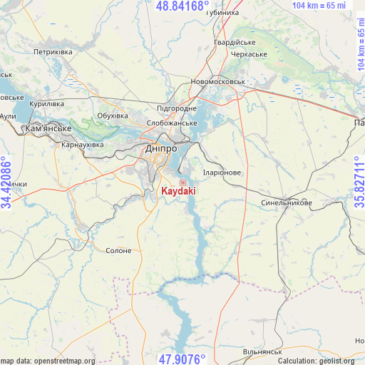
Kaydaki GPS coordinates[2]
48° 22' 36.408" North, 35° 7' 26.328" East
| Map corner | latitude | longitude |
|---|---|---|
| Upper-left | 48.84168°, | 34.42086° |
| Center: | 48.37678°, | 35.12398° |
| Lower-right: | 47.9076°, | 35.82711° |
| Map W x H: | 103.9×103.9 km | = 64.6×64.6mi |
| max Lat: | 52.18903° ⇑47.9% North |
| Kaydaki: | 48.37678° |
| min Lat: | ⇓52.1% South 44.39214° |
| min Long | Kaydaki | max Long |
| 22.20555° | 35.12398° | 40.13222° |
| W 81.5%⇐ | ⇒18.5% E |
Elevation
Elevation of Kaydaki is 134 m = 440 ft, and this is 21.8 m = 72 ft below average elevation for this country.
| Max E: |
886 m = 2907 ft | 50.1% |
| Avg. | 155.8 m = 511 ft | |
| Kaydaki | 134 m = 440 ft | |
Min E: |
-3 m = -10 ft | 49.9% |
See also: Ukraine elevation on elevation.city.
Geographical zone
Kaydaki is located in North temperate zone (between Tropic of Cancer and the Arctic Circle). Distance of this North polar circle is 2022.2 km =1256.5 mi to North.| Distance of | km | miles | from Kaydaki |
|---|---|---|---|
| North Pole | 4628.1 | 2875.8 | to North |
| Arctic Circle | 2022.2 | 1256.5 | to North |
| Tropic Cancer | 2773.1 | 1723.1 | to South |
| Equator | 5379 | 3342.4 | to South |


Nearby cities:
15 places around Kaydaki: (largest is in red/bold)
• Aviatorske
3.3 km =2.1 mi,  251°
251°
• Dnipro
11.1 km =6.9 mi,  325°
325°
• Hubynykha
49.1 km =30.5 mi,  11°
11°
• Kamianske
41.3 km =25.7 mi,  291°
291°
• Khashchevoye
39.4 km =24.5 mi,  23°
23°
• Krynychky
48.5 km =30.1 mi,  269°
269°
• Melioratyvne
35.4 km =22 mi,  37°
37°
• Novomoskovs’k
30.4 km =18.9 mi, 17°
• Novopokrovka
52.1 km =32.4 mi,  227°
227°
• Partyzans’ke
32.9 km =20.4 mi,  315°
315°
• Pidhorodne
22.1 km =13.7 mi,  356°
356°
• Solone
26.4 km =16.4 mi,  224°
224°
• Spas’ke
32.6 km =20.3 mi,  350°
350°
• Surs’ko-Mykhaylivka
31.5 km =19.6 mi, 248°
• Synel’nykove
29.8 km =18.5 mi,  102°
102°
Sources, notices
• [Note1] Compared only with cities in Ukraine existing in our database
• [Src1] Map data: © OpenStreetMap contributors (CC-BY-SA)
• [Src2] Other city data from geonames.org with taken over terms of usage.
• [Src3] Geographical zone / Annual Mean Temperature by Robert A. Rohde @ Wikipedia
