Kamianske geodata
Kamianske (Dnipropetrovsk) is a seat of a second-order administrative division; located in Ukraine in Europe/Kiev (GMT+3) time zone. With population of 248,575 people, there are 25 cities with bigger population in this country. Compared to other cities in Ukraine, 55.5% of cities are located further ↓South; 74.7% of cities are located further ←West and 63.9% of cities have higher elevation than Kamianske. Note1


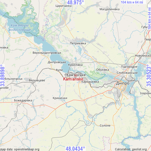
Kamianske GPS coordinates[2]
48° 30' 40.824" North, 34° 36' 7.56" East
| Map corner | latitude | longitude |
|---|---|---|
| Upper-left | 48.975°, | 33.89898° |
| Center: | 48.51134°, | 34.6021° |
| Lower-right: | 48.0434°, | 35.30523° |
| Map W x H: | 103.6×103.6 km | = 64.4×64.4mi |
| max Lat: | 52.18903° ⇑44.5% North |
| Kamianske: | 48.51134° |
| min Lat: | ⇓55.5% South 44.39214° |
| min Long | Kamianske | max Long |
| 22.20555° | 34.6021° | 40.13222° |
| W 74.7%⇐ | ⇒25.3% E |
Elevation
Elevation of Kamianske is 94 m = 308 ft, and this is 61.8 m = 203 ft below average elevation for this country.
| Max E: |
886 m = 2907 ft | 63.9% |
| Avg. | 155.8 m = 511 ft | |
| Kamianske | 94 m = 308 ft | |
Min E: |
-3 m = -10 ft | 36.1% |
See also: Kamianske elevation on elevation.city.
Geographical zone
Kamianske is located in North temperate zone (between Tropic of Cancer and the Arctic Circle). Distance of this North polar circle is 2007.2 km =1247.2 mi to North.| Distance of | km | miles | from Kamianske |
|---|---|---|---|
| North Pole | 4613.1 | 2866.4 | to North |
| Arctic Circle | 2007.2 | 1247.2 | to North |
| Tropic Cancer | 2788 | 1732.4 | to South |
| Equator | 5394 | 3351.7 | to South |


Nearby cities:
15 places around Kamianske: (largest is in red/bold)
• Auly
12.1 km =7.5 mi,  300°
300°
• Aviatorske
38.8 km =24.1 mi,  114°
114°
• Dnipro
32.7 km =20.3 mi,  100°
100°
• Kaydaki
41.3 km =25.7 mi, 111°
• Krynychky
18.1 km =11.2 mi,  213°
213°
• Novomoskovs’k
49.4 km =30.7 mi,  73°
73°
• Novomykolayivka
17.5 km =10.9 mi,  286°
286°
• Partyzans’ke
17.4 km =10.8 mi,  61°
61°
• Petrykivka
24.3 km =15.1 mi,  5°
5°
• Pidhorodne
37.8 km =23.5 mi,  79°
79°
• Solone
39.2 km =24.4 mi,  149°
149°
• Spas’ke
37.4 km =23.2 mi, 62°
• Surs’ko-Mykhaylivka
28.2 km =17.5 mi,  160°
160°
• Tsarychanka
48.2 km =30 mi,  349°
349°
• Verkhn’odniprovs’k
25.2 km =15.7 mi,  308°
308°
Sources, notices
• [Note1] Compared only with cities in Ukraine existing in our database
• [Src1] Map data: © OpenStreetMap contributors (CC-BY-SA)
• [Src2] Other city data from geonames.org with taken over terms of usage.
• [Src3] Geographical zone / Annual Mean Temperature by Robert A. Rohde @ Wikipedia
