Rava-Rus’ka geodata
Rava-Rus’ka (Lviv) is a populated place; located in Ukraine in Europe/Kiev (GMT+3) time zone. With population of 8,328 people, there are 424 cities with bigger population in this country. Compared to other cities in Ukraine, 86.9% of cities are located further ↓South; 94.8% of cities are located further →East and 78.8% of cities have lower elevation than Rava-Rus’ka. Note1


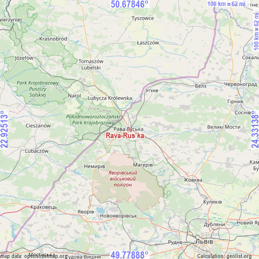
Rava-Rus’ka GPS coordinates[2]
50° 13' 50.844" North, 23° 37' 41.7" East
| Map corner | latitude | longitude |
|---|---|---|
| Upper-left | 50.67846°, | 22.92513° |
| Center: | 50.23079°, | 23.62825° |
| Lower-right: | 49.77888°, | 24.33138° |
| Map W x H: | 100×100 km | = 62.1×62.1mi |
| max Lat: | 52.18903° ⇑13.1% North |
| Rava-Rus’ka: | 50.23079° |
| min Lat: | ⇓86.9% South 44.39214° |
| min Long | Rava-Rus’ka | max Long |
| 22.20555° | 23.62825° | 40.13222° |
| W 5.2%⇐ | ⇒94.8% E |
Elevation
Elevation of Rava-Rus’ka is 241 m = 791 ft, and this is 85.2 m = 280 ft above average elevation for this country.
| Max E: |
886 m = 2907 ft | 21.2% |
| Rava-Rus’ka | 241 m 791 ft | |
| Avg. | 155.8 m = 511 ft | |
Min E: |
-3 m = -10 ft | 78.8% |
See also: Ukraine elevation on elevation.city.
Geographical zone
Rava-Rus’ka is located in North temperate zone (between Tropic of Cancer and the Arctic Circle). Distance of this North polar circle is 1816 km =1128.4 mi to North.| Distance of | km | miles | from Rava-Rus’ka |
|---|---|---|---|
| North Pole | 4421.9 | 2747.6 | to North |
| Arctic Circle | 1816 | 1128.4 | to North |
| Tropic Cancer | 2979.2 | 1851.2 | to South |
| Equator | 5585.1 | 3470.4 | to South |


Nearby cities:
15 places around Rava-Rus’ka: (largest is in red/bold)
• Belz
31.7 km =19.7 mi,  57°
57°
• Hlyns'k
27.1 km =16.8 mi,  134°
134°
• Ivano-Frankove
35.3 km =21.9 mi,  168°
168°
• Krekhiv
24 km =14.9 mi,  146°
146°
• Novoyavorivs'k
33.6 km =20.9 mi,  186°
186°
• Potelych
6.3 km =3.9 mi,  246°
246°
• Richky
5.3 km =3.3 mi,  13°
13°
• Shklo
31.1 km =19.3 mi, 191°
• Silets’
41.6 km =25.8 mi,  79°
79°
• Starychi
28.3 km =17.6 mi, 190°
• Uhniv
17.5 km =10.9 mi,  29°
29°
• Verblyany
25.1 km =15.6 mi,  215°
215°
• Vereshitsa
27 km =16.8 mi,  179°
179°
• Yavoriv
36.9 km =22.9 mi,  208°
208°
• Zhovkva
31.1 km =19.3 mi, 128°
Sources, notices
• [Note1] Compared only with cities in Ukraine existing in our database
• [Src1] Map data: © OpenStreetMap contributors (CC-BY-SA)
• [Src2] Other city data from geonames.org with taken over terms of usage.
• [Src3] Geographical zone / Annual Mean Temperature by Robert A. Rohde @ Wikipedia
