Chernovo geodata
Chernovo (Republic of Crimea) is a seat of a third-order administrative division; located in Ukraine in Europe/Simferopol (GMT+3) time zone. With population of 843 people, there are 1464 cities with bigger population in this country. Compared to other cities in Ukraine, 76.7% of cities are located further ↑North; 60.8% of cities are located further ←West and 80.6% of cities have higher elevation than Chernovo. Note1
Administrative division(s):
- Level 1: Republic of Crimea
- Level 2: Pervomayskiy rayon
- Level 3: Chernovskoye sel'skoye poselenye


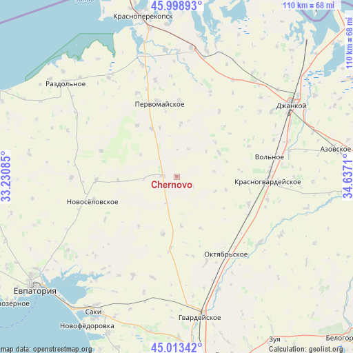
Chernovo GPS coordinates[2]
45° 30' 29.988" North, 33° 56' 2.292" East
| Map corner | latitude | longitude |
|---|---|---|
| Upper-left | 45.99893°, | 33.23085° |
| Center: | 45.50833°, | 33.93397° |
| Lower-right: | 45.01342°, | 34.6371° |
| Map W x H: | 109.6×109.6 km | = 68.1×68.1mi |
| max Lat: | 52.18903° ⇑76.7% North |
| Chernovo: | 45.50833° |
| min Lat: | ⇓23.3% South 44.39214° |
| min Long | Chernovo | max Long |
| 22.20555° | 33.93397° | 40.13222° |
| W 60.8%⇐ | ⇒39.2% E |
Elevation
Elevation of Chernovo is 41 m = 135 ft, and this is 114.8 m = 377 ft below average elevation for this country.
| Max E: |
886 m = 2907 ft | 80.6% |
| Avg. | 155.8 m = 511 ft | |
| Chernovo | 41 m = 135 ft | |
Min E: |
-3 m = -10 ft | 19.4% |
See also: Ukraine elevation on elevation.city.
Geographical zone
Chernovo is located in North temperate zone (between Tropic of Cancer and the Arctic Circle). Distance of this North polar circle is 2341.1 km =1454.7 mi to North.| Distance of | km | miles | from Chernovo |
|---|---|---|---|
| North Pole | 4947 | 3073.9 | to North |
| Arctic Circle | 2341.1 | 1454.7 | to North |
| Tropic Cancer | 2454.1 | 1524.9 | to South |
| Equator | 5060.1 | 3144.2 | to South |


Nearby cities:
15 places around Chernovo: (largest is in red/bold)
• Aleksandrovka
15 km =9.3 mi,  59°
59°
• Grishino
16.9 km =10.5 mi,  331°
331°
• Hvardiiske
9.3 km =5.8 mi,  20°
20°
• Il’inka
19.2 km =11.9 mi,  218°
218°
• Karpovka
11.5 km =7.1 mi,  81°
81°
• Klepinino
19.5 km =12.1 mi, 83°
• Kotel’nikovo
17.4 km =10.8 mi,  155°
155°
• Krasnaya Polyana
15.6 km =9.7 mi,  104°
104°
• Kremnevka
12.6 km =7.8 mi,  110°
110°
• Oktyabr’skoye
16.4 km =10.2 mi,  4°
4°
• Sary-Bash
13.4 km =8.3 mi,  301°
301°
• Sizovka
18.3 km =11.4 mi,  194°
194°
• Stakhanovka
15.4 km =9.6 mi,  175°
175°
• Susanino
18.4 km =11.4 mi,  266°
266°
• Voykovo
4.6 km =2.9 mi,  275°
275°
Sources, notices
• [Note1] Compared only with cities in Ukraine existing in our database
• [Src1] Map data: © OpenStreetMap contributors (CC-BY-SA)
• [Src2] Other city data from geonames.org with taken over terms of usage.
• [Src3] Geographical zone / Annual Mean Temperature by Robert A. Rohde @ Wikipedia
