Sokal’ geodata
Sokal’ (Lviv) is a seat of a second-order administrative division; located in Ukraine in Europe/Kiev (GMT+3) time zone. With population of 21,451 people, there are 188 cities with bigger population in this country. Compared to other cities in Ukraine, 90.5% of cities are located further ↓South; 90.9% of cities are located further →East and 68% of cities have lower elevation than Sokal’. Note1


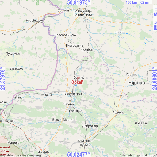
Sokal’ GPS coordinates[2]
50° 28' 27.768" North, 24° 16' 58.368" East
| Map corner | latitude | longitude |
|---|---|---|
| Upper-left | 50.91975°, | 23.57976° |
| Center: | 50.47438°, | 24.28288° |
| Lower-right: | 50.02477°, | 24.98601° |
| Map W x H: | 99.5×99.5 km | = 61.8×61.8mi |
| max Lat: | 52.18903° ⇑9.5% North |
| Sokal’: | 50.47438° |
| min Lat: | ⇓90.5% South 44.39214° |
| min Long | Sokal’ | max Long |
| 22.20555° | 24.28288° | 40.13222° |
| W 9.1%⇐ | ⇒90.9% E |
Elevation
Elevation of Sokal’ is 198 m = 650 ft, and this is 42.2 m = 138 ft above average elevation for this country.
| Max E: |
886 m = 2907 ft | 32% |
| Sokal’ | 198 m 650 ft | |
| Avg. | 155.8 m = 511 ft | |
Min E: |
-3 m = -10 ft | 68% |
See also: Ukraine elevation on elevation.city.
Geographical zone
Sokal’ is located in North temperate zone (between Tropic of Cancer and the Arctic Circle). Distance of this North polar circle is 1788.9 km =1111.6 mi to North.| Distance of | km | miles | from Sokal’ |
|---|---|---|---|
| North Pole | 4394.8 | 2730.8 | to North |
| Arctic Circle | 1788.9 | 1111.6 | to North |
| Tropic Cancer | 3006.3 | 1868 | to South |
| Equator | 5612.2 | 3487.3 | to South |


Nearby cities:
15 places around Sokal’: (largest is in red/bold)
• Belz
22.1 km =13.7 mi,  242°
242°
• Blahodatne
21.2 km =13.2 mi,  353°
353°
• Chervonohrad
9.9 km =6.2 mi,  200°
200°
• Horokhiv
34 km =21.1 mi,  84°
84°
• Ivanychi
19.1 km =11.9 mi,  16°
16°
• Kamianka-Buzka
41.1 km =25.5 mi,  173°
173°
• Kulykiv
41.9 km =26 mi,  115°
115°
• Lokachi
39 km =24.2 mi,  41°
41°
• Novovolyns’k
29.2 km =18.1 mi,  343°
343°
• Radekhiv
33.3 km =20.7 mi,  129°
129°
• Silets’
20.5 km =12.7 mi, 195°
• Staryy Dobrotvir
27.8 km =17.3 mi, 166°
• Uhniv
39.6 km =24.6 mi,  252°
252°
• Varyazh
14.2 km =8.8 mi,  288°
288°
• Volodymyr-Volynskyi
42.1 km =26.2 mi,  3°
3°
Sources, notices
• [Note1] Compared only with cities in Ukraine existing in our database
• [Src1] Map data: © OpenStreetMap contributors (CC-BY-SA)
• [Src2] Other city data from geonames.org with taken over terms of usage.
• [Src3] Geographical zone / Annual Mean Temperature by Robert A. Rohde @ Wikipedia
