Radekhiv geodata
Radekhiv (Lviv) is a seat of a second-order administrative division; located in Ukraine in Europe/Kiev (GMT+3) time zone. In our database, there are 1661 cities with bigger population. Compared to other cities in Ukraine, 87.7% of cities are located further ↓South; 88.5% of cities are located further →East and 75% of cities have lower elevation than Radekhiv. Note1


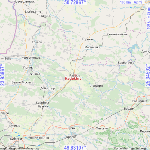
Radekhiv GPS coordinates[2]
50° 16' 56.964" North, 24° 38' 34.044" East
| Map corner | latitude | longitude |
|---|---|---|
| Upper-left | 50.72967°, | 23.93967° |
| Center: | 50.28249°, | 24.64279° |
| Lower-right: | 49.83107°, | 25.34592° |
| Map W x H: | 99.9×99.9 km | = 62.1×62.1mi |
| max Lat: | 52.18903° ⇑12.3% North |
| Radekhiv: | 50.28249° |
| min Lat: | ⇓87.7% South 44.39214° |
| min Long | Radekhiv | max Long |
| 22.20555° | 24.64279° | 40.13222° |
| W 11.5%⇐ | ⇒88.5% E |
Elevation
Elevation of Radekhiv is 227 m = 745 ft, and this is 71.2 m = 234 ft above average elevation for this country.
| Max E: |
886 m = 2907 ft | 25% |
| Radekhiv | 227 m 745 ft | |
| Avg. | 155.8 m = 511 ft | |
Min E: |
-3 m = -10 ft | 75% |
See also: Ukraine elevation on elevation.city.
Geographical zone
Radekhiv is located in North temperate zone (between Tropic of Cancer and the Arctic Circle). Distance of this North polar circle is 1810.3 km =1124.9 mi to North.| Distance of | km | miles | from Radekhiv |
|---|---|---|---|
| North Pole | 4416.2 | 2744.1 | to North |
| Arctic Circle | 1810.3 | 1124.9 | to North |
| Tropic Cancer | 2985 | 1854.8 | to South |
| Equator | 5590.9 | 3474 | to South |


Nearby cities:
15 places around Radekhiv: (largest is in red/bold)
• Berestechko
34.3 km =21.3 mi,  75°
75°
• Brody
42.1 km =26.2 mi,  120°
120°
• Bus’k
35.3 km =21.9 mi,  183°
183°
• Chervonohrad
31.3 km =19.4 mi,  292°
292°
• Horokhiv
25.8 km =16 mi,  19°
19°
• Ivanychi
44.4 km =27.6 mi,  333°
333°
• Kamianka-Buzka
28.9 km =18 mi,  227°
227°
• Krasne
41 km =25.5 mi, 182°
• Kulykiv
12.9 km =8 mi,  74°
74°
• Lopatyn
16.2 km =10.1 mi, 115°
• Olesko
39.8 km =24.7 mi,  153°
153°
• Pidhirtsi
44.4 km =27.6 mi, 147°
• Silets’
31.2 km =19.4 mi,  272°
272°
• Sokal’
33.3 km =20.7 mi,  309°
309°
• Staryy Dobrotvir
19.7 km =12.2 mi,  253°
253°
Sources, notices
• [Note1] Compared only with cities in Ukraine existing in our database
• [Src1] Map data: © OpenStreetMap contributors (CC-BY-SA)
• [Src2] Other city data from geonames.org with taken over terms of usage.
• [Src3] Geographical zone / Annual Mean Temperature by Robert A. Rohde @ Wikipedia
