Novovolyns’k geodata
Novovolyns’k (Volyn) is a populated place; located in Ukraine in Europe/Kiev (GMT+3) time zone. With population of 57,800 people, there are 81 cities with bigger population in this country. Compared to other cities in Ukraine, 93.6% of cities are located further ↓South; 91.9% of cities are located further →East and 77.7% of cities have lower elevation than Novovolyns’k. Note1


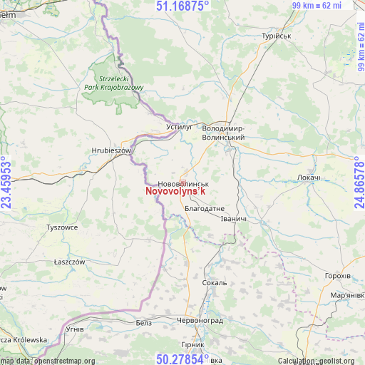
Novovolyns’k GPS coordinates[2]
50° 43' 32.736" North, 24° 9' 45.54" East
| Map corner | latitude | longitude |
|---|---|---|
| Upper-left | 51.16875°, | 23.45953° |
| Center: | 50.72576°, | 24.16265° |
| Lower-right: | 50.27854°, | 24.86578° |
| Map W x H: | 99×99 km | = 61.5×61.5mi |
| max Lat: | 52.18903° ⇑6.4% North |
| Novovolyns’k: | 50.72576° |
| min Lat: | ⇓93.6% South 44.39214° |
| min Long | Novovolyns’k | max Long |
| 22.20555° | 24.16265° | 40.13222° |
| W 8.1%⇐ | ⇒91.9% E |
Elevation
Elevation of Novovolyns’k is 237 m = 778 ft, and this is 81.2 m = 266 ft above average elevation for this country.
| Max E: |
886 m = 2907 ft | 22.3% |
| Novovolyns’k | 237 m 778 ft | |
| Avg. | 155.8 m = 511 ft | |
Min E: |
-3 m = -10 ft | 77.7% |
See also: Novovolyns’k elevation on elevation.city.
Geographical zone
Novovolyns’k is located in North temperate zone (between Tropic of Cancer and the Arctic Circle). Distance of this North polar circle is 1761 km =1094.2 mi to North.| Distance of | km | miles | from Novovolyns’k |
|---|---|---|---|
| North Pole | 4366.9 | 2713.5 | to North |
| Arctic Circle | 1761 | 1094.2 | to North |
| Tropic Cancer | 3034.3 | 1885.4 | to South |
| Equator | 5640.2 | 3504.7 | to South |


Nearby cities:
15 places around Novovolyns’k: (largest is in red/bold)
• Belz
39.8 km =24.7 mi,  196°
196°
• Blahodatne
9.2 km =5.7 mi,  138°
138°
• Chervonohrad
37.6 km =23.4 mi,  172°
172°
• Horokhiv
49 km =30.4 mi,  120°
120°
• Ivanychi
16.9 km =10.5 mi, 124°
• Liuboml
56.3 km =35 mi,  351°
351°
• Lokachi
34.3 km =21.3 mi,  87°
87°
• Oles’k
42.8 km =26.6 mi,  2°
2°
• Silets’
47.8 km =29.7 mi,  176°
176°
• Sokal’
29.2 km =18.1 mi,  163°
163°
• Staryy Dobrotvir
57 km =35.4 mi, 164°
• Turiys’k
47.4 km =29.5 mi,  32°
32°
• Uhniv
49.4 km =30.7 mi,  216°
216°
• Varyazh
24 km =14.9 mi,  191°
191°
• Volodymyr-Volynskyi
18.1 km =11.2 mi,  38°
38°
Sources, notices
• [Note1] Compared only with cities in Ukraine existing in our database
• [Src1] Map data: © OpenStreetMap contributors (CC-BY-SA)
• [Src2] Other city data from geonames.org with taken over terms of usage.
• [Src3] Geographical zone / Annual Mean Temperature by Robert A. Rohde @ Wikipedia
