Silets’ geodata
Silets’ (Lviv) is a populated place; located in Ukraine in Europe/Kiev (GMT+3) time zone. With population of 3,641 people, there are 809 cities with bigger population in this country. Compared to other cities in Ukraine, 88% of cities are located further ↓South; 91.5% of cities are located further →East and 67.1% of cities have lower elevation than Silets’. Note1


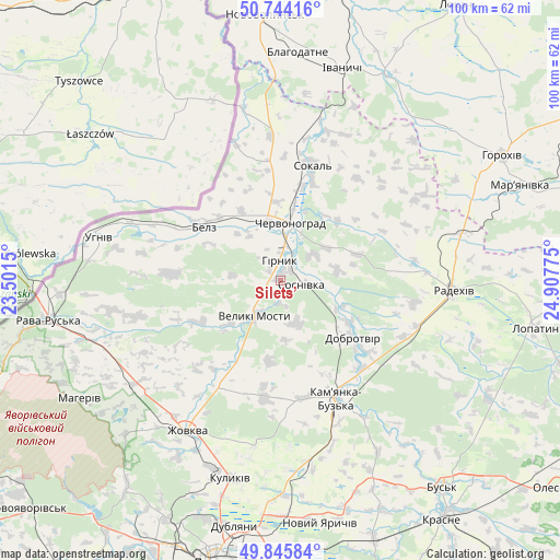
Silets’ GPS coordinates[2]
50° 17' 49.632" North, 24° 12' 16.632" East
| Map corner | latitude | longitude |
|---|---|---|
| Upper-left | 50.74416°, | 23.5015° |
| Center: | 50.29712°, | 24.20462° |
| Lower-right: | 49.84584°, | 24.90775° |
| Map W x H: | 99.9×99.9 km | = 62.1×62.1mi |
| max Lat: | 52.18903° ⇑12% North |
| Silets’: | 50.29712° |
| min Lat: | ⇓88% South 44.39214° |
| min Long | Silets’ | max Long |
| 22.20555° | 24.20462° | 40.13222° |
| W 8.5%⇐ | ⇒91.5% E |
Elevation
Elevation of Silets’ is 194 m = 636 ft, and this is 38.2 m = 125 ft above average elevation for this country.
| Max E: |
886 m = 2907 ft | 32.9% |
| Silets’ | 194 m 636 ft | |
| Avg. | 155.8 m = 511 ft | |
Min E: |
-3 m = -10 ft | 67.1% |
See also: Ukraine elevation on elevation.city.
Geographical zone
Silets’ is located in North temperate zone (between Tropic of Cancer and the Arctic Circle). Distance of this North polar circle is 1808.7 km =1123.9 mi to North.| Distance of | km | miles | from Silets’ |
|---|---|---|---|
| North Pole | 4414.5 | 2743 | to North |
| Arctic Circle | 1808.7 | 1123.9 | to North |
| Tropic Cancer | 2986.6 | 1855.8 | to South |
| Equator | 5592.5 | 3475 | to South |


Nearby cities:
15 places around Silets’: (largest is in red/bold)
• Belz
17 km =10.6 mi,  303°
303°
• Blahodatne
40.9 km =25.4 mi,  4°
4°
• Chervonohrad
10.7 km =6.6 mi,  11°
11°
• Hlyns'k
34.1 km =21.2 mi,  219°
219°
• Ivanychi
39.6 km =24.6 mi,  16°
16°
• Kamianka-Buzka
23.4 km =14.5 mi,  154°
154°
• Krekhiv
38.9 km =24.2 mi,  225°
225°
• Kulykiv
36.4 km =22.6 mi,  194°
194°
• Radekhiv
31.2 km =19.4 mi,  92°
92°
• Richky
39.7 km =24.7 mi,  266°
266°
• Sokal’
20.5 km =12.7 mi, 15°
• Staryy Dobrotvir
14.3 km =8.9 mi,  120°
120°
• Uhniv
33.3 km =20.7 mi,  283°
283°
• Varyazh
25.5 km =15.8 mi,  341°
341°
• Zhovkva
31.3 km =19.4 mi,  211°
211°
Sources, notices
• [Note1] Compared only with cities in Ukraine existing in our database
• [Src1] Map data: © OpenStreetMap contributors (CC-BY-SA)
• [Src2] Other city data from geonames.org with taken over terms of usage.
• [Src3] Geographical zone / Annual Mean Temperature by Robert A. Rohde @ Wikipedia
