Sloviansk geodata
Sloviansk (Donetsk) is a populated place; located in Ukraine in Europe/Kiev (GMT+3) time zone. With population of 124,800 people, there are 37 cities with bigger population in this country. Compared to other cities in Ukraine, 63.3% of cities are located further ↓South; 93% of cities are located further ←West and 74.9% of cities have higher elevation than Sloviansk. Note1


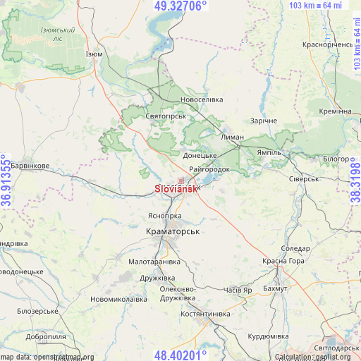
Sloviansk GPS coordinates[2]
48° 52' 0.012" North, 37° 37' 0.012" East
| Map corner | latitude | longitude |
|---|---|---|
| Upper-left | 49.32706°, | 36.91355° |
| Center: | 48.86667°, | 37.61667° |
| Lower-right: | 48.40201°, | 38.3198° |
| Map W x H: | 102.9×102.9 km | = 63.9×63.9mi |
| max Lat: | 52.18903° ⇑36.7% North |
| Sloviansk: | 48.86667° |
| min Lat: | ⇓63.3% South 44.39214° |
| min Long | Sloviansk | max Long |
| 22.20555° | 37.61667° | 40.13222° |
| W 93%⇐ | ⇒7% E |
Elevation
Elevation of Sloviansk is 61 m = 200 ft, and this is 94.8 m = 311 ft below average elevation for this country.
| Max E: |
886 m = 2907 ft | 74.9% |
| Avg. | 155.8 m = 511 ft | |
| Sloviansk | 61 m = 200 ft | |
Min E: |
-3 m = -10 ft | 25.1% |
See also: Sloviansk elevation on elevation.city.
Geographical zone
Sloviansk is located in North temperate zone (between Tropic of Cancer and the Arctic Circle). Distance of this North polar circle is 1967.7 km =1222.7 mi to North.| Distance of | km | miles | from Sloviansk |
|---|---|---|---|
| North Pole | 4573.6 | 2841.9 | to North |
| Arctic Circle | 1967.7 | 1222.7 | to North |
| Tropic Cancer | 2827.5 | 1756.9 | to South |
| Equator | 5433.5 | 3376.2 | to South |


Nearby cities:
15 places around Sloviansk: (largest is in red/bold)
• Chasiv Yar
35.1 km =21.8 mi,  149°
149°
• Drobysheve
21.1 km =13.1 mi,  22°
22°
• Druzhkivka
26.7 km =16.6 mi,  190°
190°
• Kramators’k
16.6 km =10.3 mi,  195°
195°
• Krasnotorka
21.4 km =13.3 mi, 196°
• Kryva Luka
21 km =13 mi,  87°
87°
• Lyman
19.2 km =11.9 mi,  45°
45°
• Novoselivka
23.3 km =14.5 mi,  14°
14°
• Sivers’k
35.4 km =22 mi, 89°
• Studenok
26.7 km =16.6 mi,  339°
339°
• Svyatogorsk
18.9 km =11.7 mi,  348°
348°
• Terny
35.5 km =22.1 mi, 45°
• Yampil’
26 km =16.2 mi,  72°
72°
• Yats’kivka
35.5 km =22.1 mi, 348°
• Zarichne
28.9 km =18 mi, 52°
In other languages:
- In German: Slowjansk
- In Italian: Slovjansk
- In Russian: Славянск
- In Chinese: 斯拉維揚斯克
Sources, notices
• [Note1] Compared only with cities in Ukraine existing in our database
• [Src1] Map data: © OpenStreetMap contributors (CC-BY-SA)
• [Src2] Other city data from geonames.org with taken over terms of usage.
• [Src3] Geographical zone / Annual Mean Temperature by Robert A. Rohde @ Wikipedia
