Kramators’k geodata
Kramators’k (Donetsk) is a populated place; located in Ukraine in Europe/Kiev (GMT+3) time zone. With population of 173,700 people, there are 32 cities with bigger population in this country. Compared to other cities in Ukraine, 60.9% of cities are located further ↓South; 92.8% of cities are located further ←West and 70.3% of cities have higher elevation than Kramators’k. Note1


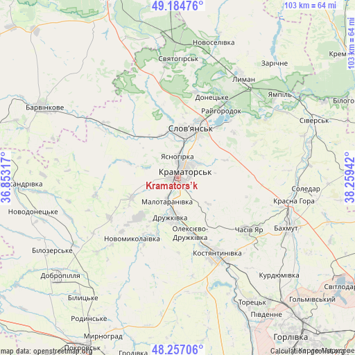
Kramators’k GPS coordinates[2]
48° 43' 22.98" North, 37° 33' 22.644" East
| Map corner | latitude | longitude |
|---|---|---|
| Upper-left | 49.18476°, | 36.85317° |
| Center: | 48.72305°, | 37.55629° |
| Lower-right: | 48.25706°, | 38.25942° |
| Map W x H: | 103.2×103.1 km | = 64.1×64.1mi |
| max Lat: | 52.18903° ⇑39.1% North |
| Kramators’k: | 48.72305° |
| min Lat: | ⇓60.9% South 44.39214° |
| min Long | Kramators’k | max Long |
| 22.20555° | 37.55629° | 40.13222° |
| W 92.8%⇐ | ⇒7.2% E |
Elevation
Elevation of Kramators’k is 74 m = 243 ft, and this is 81.8 m = 268 ft below average elevation for this country.
| Max E: |
886 m = 2907 ft | 70.3% |
| Avg. | 155.8 m = 511 ft | |
| Kramators’k | 74 m = 243 ft | |
Min E: |
-3 m = -10 ft | 29.7% |
See also: Kramators’k elevation on elevation.city.
Geographical zone
Kramators’k is located in North temperate zone (between Tropic of Cancer and the Arctic Circle). Distance of this North polar circle is 1983.7 km =1232.6 mi to North.| Distance of | km | miles | from Kramators’k |
|---|---|---|---|
| North Pole | 4589.6 | 2851.8 | to North |
| Arctic Circle | 1983.7 | 1232.6 | to North |
| Tropic Cancer | 2811.6 | 1747 | to South |
| Equator | 5417.5 | 3366.3 | to South |


Nearby cities:
15 places around Kramators’k: (largest is in red/bold)
• Bakhmut
35.5 km =22.1 mi,  113°
113°
• Chasiv Yar
26.4 km =16.4 mi,  123°
123°
• Drobysheve
37.6 km =23.4 mi,  19°
19°
• Druzhkivka
10.3 km =6.4 mi,  181°
181°
• Kostyantynivka
24.4 km =15.2 mi,  152°
152°
• Krasnotorka
4.9 km =3 mi,  200°
200°
• Kryva Luka
30.4 km =18.9 mi,  56°
56°
• Lyman
34.6 km =21.5 mi,  31°
31°
• Novoselivka
39.9 km =24.8 mi,  14°
14°
• Shcherbynivka
40.4 km =25.1 mi, 154°
• Sloviansk
16.6 km =10.3 mi, 15°
• Soledar
39.4 km =24.5 mi,  97°
97°
• Studenok
41.2 km =25.6 mi,  352°
352°
• Svyatogorsk
34.5 km =21.4 mi,  1°
1°
• Yampil’
37.6 km =23.4 mi,  51°
51°
Sources, notices
• [Note1] Compared only with cities in Ukraine existing in our database
• [Src1] Map data: © OpenStreetMap contributors (CC-BY-SA)
• [Src2] Other city data from geonames.org with taken over terms of usage.
• [Src3] Geographical zone / Annual Mean Temperature by Robert A. Rohde @ Wikipedia
