Dublyany geodata
Dublyany (Lviv) is a populated place; located in Ukraine in Europe/Kiev (GMT+3) time zone. With population of 2,086 people, there are 1092 cities with bigger population in this country. Compared to other cities in Ukraine, 74.3% of cities are located further ↓South; 96.5% of cities are located further →East and 86% of cities have lower elevation than Dublyany. Note1


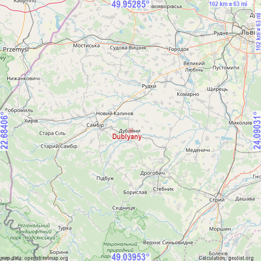
Dublyany GPS coordinates[2]
49° 29' 53.952" North, 23° 23' 13.848" East
| Map corner | latitude | longitude |
|---|---|---|
| Upper-left | 49.95285°, | 22.68406° |
| Center: | 49.49832°, | 23.38718° |
| Lower-right: | 49.03953°, | 24.09031° |
| Map W x H: | 101.6×101.5 km | = 63.1×63.1mi |
| max Lat: | 52.18903° ⇑25.7% North |
| Dublyany: | 49.49832° |
| min Lat: | ⇓74.3% South 44.39214° |
| min Long | Dublyany | max Long |
| 22.20555° | 23.38718° | 40.13222° |
| W 3.5%⇐ | ⇒96.5% E |
Elevation
Elevation of Dublyany is 281 m = 922 ft, and this is 125.2 m = 411 ft above average elevation for this country.
| Max E: |
886 m = 2907 ft | 14% |
| Dublyany | 281 m 922 ft | |
| Avg. | 155.8 m = 511 ft | |
Min E: |
-3 m = -10 ft | 86% |
See also: Ukraine elevation on elevation.city.
Geographical zone
Dublyany is located in North temperate zone (between Tropic of Cancer and the Arctic Circle). Distance of this North polar circle is 1897.5 km =1179.1 mi to North.| Distance of | km | miles | from Dublyany |
|---|---|---|---|
| North Pole | 4503.4 | 2798.3 | to North |
| Arctic Circle | 1897.5 | 1179.1 | to North |
| Tropic Cancer | 2897.8 | 1800.6 | to South |
| Equator | 5503.7 | 3419.8 | to South |


Nearby cities:
15 places around Dublyany: (largest is in red/bold)
• Boryslav
23.8 km =14.8 mi,  172°
172°
• Drohobych
18.6 km =11.6 mi,  152°
152°
• Komarno
26.7 km =16.6 mi,  57°
57°
• Krukenychi
27 km =16.8 mi,  321°
321°
• Medenychi
27.3 km =17 mi,  106°
106°
• Pidbuzh
20.7 km =12.9 mi,  208°
208°
• Pnikut
29.7 km =18.5 mi, 322°
• Ralivka
10.8 km =6.7 mi,  270°
270°
• Rudky
18.7 km =11.6 mi,  22°
22°
• Rykhtychi
17.6 km =10.9 mi,  135°
135°
• Sambir
13.9 km =8.6 mi,  279°
279°
• Staryy Sambir
28.7 km =17.8 mi,  256°
256°
• Stebnyk
26 km =16.2 mi, 150°
• Truskavets’
25.9 km =16.1 mi,  160°
160°
• Voyutychi
21.1 km =13.1 mi,  286°
286°
Sources, notices
• [Note1] Compared only with cities in Ukraine existing in our database
• [Src1] Map data: © OpenStreetMap contributors (CC-BY-SA)
• [Src2] Other city data from geonames.org with taken over terms of usage.
• [Src3] Geographical zone / Annual Mean Temperature by Robert A. Rohde @ Wikipedia
