Sambir geodata
Sambir (Lviv) is a seat of a second-order administrative division; located in Ukraine in Europe/Kiev (GMT+3) time zone. With population of 35,197 people, there are 126 cities with bigger population in this country. Compared to other cities in Ukraine, 74.6% of cities are located further ↓South; 97.4% of cities are located further →East and 90.2% of cities have lower elevation than Sambir. Note1


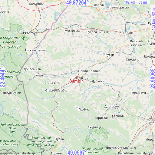
Sambir GPS coordinates[2]
49° 31' 5.88" North, 23° 11' 51.072" East
| Map corner | latitude | longitude |
|---|---|---|
| Upper-left | 49.97264°, | 22.4944° |
| Center: | 49.5183°, | 23.19752° |
| Lower-right: | 49.0597°, | 23.90065° |
| Map W x H: | 101.5×101.5 km | = 63.1×63.1mi |
| max Lat: | 52.18903° ⇑25.4% North |
| Sambir: | 49.5183° |
| min Lat: | ⇓74.6% South 44.39214° |
| min Long | Sambir | max Long |
| 22.20555° | 23.19752° | 40.13222° |
| W 2.6%⇐ | ⇒97.4% E |
Elevation
Elevation of Sambir is 308 m = 1010 ft, and this is 152.2 m = 499 ft above average elevation for this country.
| Max E: |
886 m = 2907 ft | 9.8% |
| Sambir | 308 m 1010 ft | |
| Avg. | 155.8 m = 511 ft | |
Min E: |
-3 m = -10 ft | 90.2% |
See also: Ukraine elevation on elevation.city.
Geographical zone
Sambir is located in North temperate zone (between Tropic of Cancer and the Arctic Circle). Distance of this North polar circle is 1895.3 km =1177.7 mi to North.| Distance of | km | miles | from Sambir |
|---|---|---|---|
| North Pole | 4501.1 | 2796.9 | to North |
| Arctic Circle | 1895.3 | 1177.7 | to North |
| Tropic Cancer | 2900 | 1802 | to South |
| Equator | 5505.9 | 3421.2 | to South |


Nearby cities:
15 places around Sambir: (largest is in red/bold)
• Boryslav
30.9 km =19.2 mi,  146°
146°
• Dobromyl’
30.3 km =18.8 mi,  281°
281°
• Drohobych
29.1 km =18.1 mi,  130°
130°
• Dublyany
13.9 km =8.6 mi,  99°
99°
• Khyriv
24.8 km =15.4 mi,  274°
274°
• Krukenychi
19.1 km =11.9 mi,  350°
350°
• Murovane
18.8 km =11.7 mi, 271°
• Pidbuzh
20.7 km =12.9 mi,  169°
169°
• Pnikut
21.9 km =13.6 mi, 348°
• Ralivka
3.5 km =2.2 mi, 125°
• Rudky
25.7 km =16 mi,  54°
54°
• Rykhtychi
29.9 km =18.6 mi,  119°
119°
• Skelivka
16.9 km =10.5 mi, 277°
• Staryy Sambir
16.8 km =10.4 mi,  238°
238°
• Voyutychi
7.6 km =4.7 mi,  299°
299°
Sources, notices
• [Note1] Compared only with cities in Ukraine existing in our database
• [Src1] Map data: © OpenStreetMap contributors (CC-BY-SA)
• [Src2] Other city data from geonames.org with taken over terms of usage.
• [Src3] Geographical zone / Annual Mean Temperature by Robert A. Rohde @ Wikipedia
