Reni geodata
Reni (Odesa) is a seat of a second-order administrative division; located in Ukraine in Europe/Kiev (GMT+3) time zone. With population of 19,719 people, there are 203 cities with bigger population in this country. Compared to other cities in Ukraine, 78.3% of cities are located further ↑North; 75.2% of cities are located further →East and 98% of cities have higher elevation than Reni. Note1


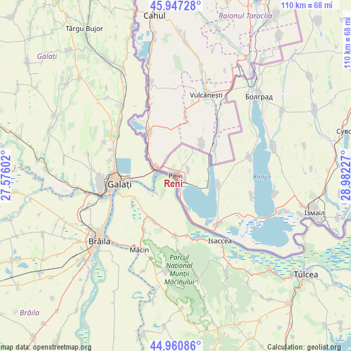
Reni GPS coordinates[2]
45° 27' 22.428" North, 28° 16' 44.904" East
| Map corner | latitude | longitude |
|---|---|---|
| Upper-left | 45.94728°, | 27.57602° |
| Center: | 45.45623°, | 28.27914° |
| Lower-right: | 44.96086°, | 28.98227° |
| Map W x H: | 109.7×109.7 km | = 68.2×68.2mi |
| max Lat: | 52.18903° ⇑78.3% North |
| Reni: | 45.45623° |
| min Lat: | ⇓21.7% South 44.39214° |
| min Long | Reni | max Long |
| 22.20555° | 28.27914° | 40.13222° |
| W 24.8%⇐ | ⇒75.2% E |
Elevation
Elevation of Reni is 7 m = 23 ft, and this is 148.8 m = 488 ft below average elevation for this country.
| Max E: |
886 m = 2907 ft | 98% |
| Avg. | 155.8 m = 511 ft | |
| Reni | 7 m = 23 ft | |
Min E: |
-3 m = -10 ft | 2% |
See also: Ukraine elevation on elevation.city.
Geographical zone
Reni is located in North temperate zone (between Tropic of Cancer and the Arctic Circle). Distance of this North polar circle is 2346.9 km =1458.3 mi to North.| Distance of | km | miles | from Reni |
|---|---|---|---|
| North Pole | 4952.8 | 3077.5 | to North |
| Arctic Circle | 2346.9 | 1458.3 | to North |
| Tropic Cancer | 2448.3 | 1521.3 | to South |
| Equator | 5054.3 | 3140.6 | to South |


Nearby cities:
15 places around Reni: (largest is in red/bold)
• Artsyz
106.6 km =66.2 mi,  56°
56°
• Bolhrad
36.3 km =22.6 mi,  46°
46°
• Broska
40.4 km =25.1 mi,  103°
103°
• Dmytrivka
79.4 km =49.3 mi,  43°
43°
• Horodnye
65.5 km =40.7 mi, 42°
• Izmayil
45.4 km =28.2 mi,  105°
105°
• Kalcheva
52.1 km =32.4 mi, 53°
• Kiliya
76.8 km =47.7 mi,  90°
90°
• Novi Troyany
70.3 km =43.7 mi, 39°
• Ozerne
31.5 km =19.6 mi, 100°
• Shevchenkove
82.9 km =51.5 mi,  82°
82°
• Tarutyne
105.7 km =65.7 mi, 39°
• Vylkove
102.1 km =63.4 mi, 93°
• Vynohradivka
33.8 km =21 mi, 42°
• Zaliznychne
41.7 km =25.9 mi, 38°
Sources, notices
• [Note1] Compared only with cities in Ukraine existing in our database
• [Src1] Map data: © OpenStreetMap contributors (CC-BY-SA)
• [Src2] Other city data from geonames.org with taken over terms of usage.
• [Src3] Geographical zone / Annual Mean Temperature by Robert A. Rohde @ Wikipedia
