Vylkove geodata
Vylkove (Odesa) is a populated place; located in Ukraine in Europe/Kiev (GMT+3) time zone. With population of 8,916 people, there are 403 cities with bigger population in this country. Compared to other cities in Ukraine, 79.5% of cities are located further ↑North; 69.8% of cities are located further →East and 99.8% of cities have higher elevation than Vylkove. Note1


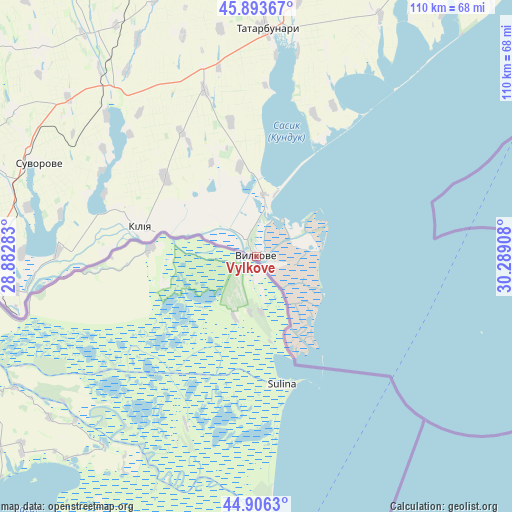
Vylkove GPS coordinates[2]
45° 24' 7.704" North, 29° 35' 9.42" East
| Map corner | latitude | longitude |
|---|---|---|
| Upper-left | 45.89367°, | 28.88283° |
| Center: | 45.40214°, | 29.58595° |
| Lower-right: | 44.9063°, | 30.28908° |
| Map W x H: | 109.8×109.8 km | = 68.2×68.2mi |
| max Lat: | 52.18903° ⇑79.5% North |
| Vylkove: | 45.40214° |
| min Lat: | ⇓20.5% South 44.39214° |
| min Long | Vylkove | max Long |
| 22.20555° | 29.58595° | 40.13222° |
| W 30.2%⇐ | ⇒69.8% E |
Elevation
Elevation of Vylkove is 1 m = 3 ft, and this is 154.8 m = 508 ft below average elevation for this country.
| Max E: |
886 m = 2907 ft | 99.8% |
| Avg. | 155.8 m = 511 ft | |
| Vylkove | 1 m = 3 ft | |
Min E: |
-3 m = -10 ft | 0.2% |
See also: Ukraine elevation on elevation.city.
Geographical zone
Vylkove is located in North temperate zone (between Tropic of Cancer and the Arctic Circle). Distance of this North polar circle is 2352.9 km =1462 mi to North.| Distance of | km | miles | from Vylkove |
|---|---|---|---|
| North Pole | 4958.8 | 3081.3 | to North |
| Arctic Circle | 2352.9 | 1462 | to North |
| Tropic Cancer | 2442.3 | 1517.6 | to South |
| Equator | 5048.2 | 3136.8 | to South |


Nearby cities:
15 places around Vylkove: (largest is in red/bold)
• Artsyz
66.9 km =41.6 mi,  348°
348°
• Bolhrad
81.8 km =50.8 mi,  292°
292°
• Broska
62.8 km =39 mi,  267°
267°
• Dmytrivka
78.6 km =48.8 mi,  323°
323°
• Horodnye
79 km =49.1 mi,  313°
313°
• Izmayil
58.5 km =36.4 mi,  264°
264°
• Kalcheva
70.7 km =43.9 mi,  301°
301°
• Kiliya
25.8 km =16 mi,  283°
283°
• Kulevcha
75 km =46.6 mi,  21°
21°
• Ozerne
71.1 km =44.2 mi, 270°
• Plakhtiyivka
78.4 km =48.7 mi,  7°
7°
• Sarata
68.9 km =42.8 mi, 5°
• Shevchenkove
26.1 km =16.2 mi, 311°
• Tatarbunary
48.4 km =30.1 mi,  2°
2°
• Zorya
66 km =41 mi, 7°
Sources, notices
• [Note1] Compared only with cities in Ukraine existing in our database
• [Src1] Map data: © OpenStreetMap contributors (CC-BY-SA)
• [Src2] Other city data from geonames.org with taken over terms of usage.
• [Src3] Geographical zone / Annual Mean Temperature by Robert A. Rohde @ Wikipedia
