Broska geodata
Broska (Odesa) is a populated place; located in Ukraine in Europe/Kiev (GMT+3) time zone. With population of 3,586 people, there are 818 cities with bigger population in this country. Compared to other cities in Ukraine, 80.6% of cities are located further ↑North; 73.6% of cities are located further →East and 90.9% of cities have higher elevation than Broska. Note1


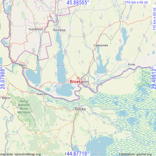
Broska GPS coordinates[2]
45° 22' 23.772" North, 28° 46' 58.8" East
| Map corner | latitude | longitude |
|---|---|---|
| Upper-left | 45.86505°, | 28.07988° |
| Center: | 45.37327°, | 28.783° |
| Lower-right: | 44.87718°, | 29.48613° |
| Map W x H: | 109.8×109.8 km | = 68.2×68.2mi |
| max Lat: | 52.18903° ⇑80.6% North |
| Broska: | 45.37327° |
| min Lat: | ⇓19.4% South 44.39214° |
| min Long | Broska | max Long |
| 22.20555° | 28.783° | 40.13222° |
| W 26.4%⇐ | ⇒73.6% E |
Elevation
Elevation of Broska is 18 m = 59 ft, and this is 137.8 m = 452 ft below average elevation for this country.
| Max E: |
886 m = 2907 ft | 90.9% |
| Avg. | 155.8 m = 511 ft | |
| Broska | 18 m = 59 ft | |
Min E: |
-3 m = -10 ft | 9.1% |
See also: Ukraine elevation on elevation.city.
Geographical zone
Broska is located in North temperate zone (between Tropic of Cancer and the Arctic Circle). Distance of this North polar circle is 2356.1 km =1464 mi to North.| Distance of | km | miles | from Broska |
|---|---|---|---|
| North Pole | 4962 | 3083.2 | to North |
| Arctic Circle | 2356.1 | 1464 | to North |
| Tropic Cancer | 2439.1 | 1515.6 | to South |
| Equator | 5045 | 3134.8 | to South |


Nearby cities:
15 places around Broska: (largest is in red/bold)
• Artsyz
84.7 km =52.6 mi,  35°
35°
• Bolhrad
36.8 km =22.9 mi,  339°
339°
• Dmytrivka
68.4 km =42.5 mi,  13°
13°
• Horodnye
57.8 km =35.9 mi, 5°
• Izmayil
5.2 km =3.2 mi,  120°
120°
• Kalcheva
40.6 km =25.2 mi,  3°
3°
• Kiliya
38.6 km =24 mi,  76°
76°
• Novi Troyany
63.6 km =39.5 mi, 5°
• Ozerne
9 km =5.6 mi,  291°
291°
• Reni
40.4 km =25.1 mi,  283°
283°
• Shevchenkove
47.5 km =29.5 mi,  64°
64°
• Tatarbunary
82.7 km =51.4 mi,  51°
51°
• Vylkove
62.8 km =39 mi,  87°
87°
• Vynohradivka
38 km =23.6 mi,  334°
334°
• Zaliznychne
43.8 km =27.2 mi, 342°
Sources, notices
• [Note1] Compared only with cities in Ukraine existing in our database
• [Src1] Map data: © OpenStreetMap contributors (CC-BY-SA)
• [Src2] Other city data from geonames.org with taken over terms of usage.
• [Src3] Geographical zone / Annual Mean Temperature by Robert A. Rohde @ Wikipedia
