Ray geodata
Ray (Ternopil) is a populated place; located in Ukraine in Europe/Kiev (GMT+3) time zone. With population of 726 people, there are 1521 cities with bigger population in this country. Compared to other cities in Ukraine, 73.5% of cities are located further ↓South; 86.6% of cities are located further →East and 90.9% of cities have lower elevation than Ray. Note1


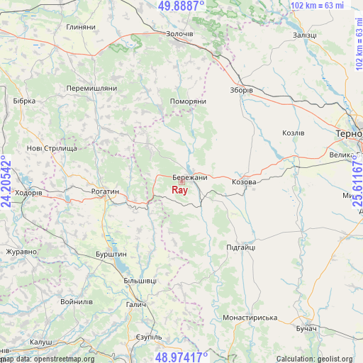
Ray GPS coordinates[2]
49° 26' 0.852" North, 24° 54' 30.744" East
| Map corner | latitude | longitude |
|---|---|---|
| Upper-left | 49.8887°, | 24.20542° |
| Center: | 49.43357°, | 24.90854° |
| Lower-right: | 48.97417°, | 25.61167° |
| Map W x H: | 101.7×101.7 km | = 63.2×63.2mi |
| max Lat: | 52.18903° ⇑26.5% North |
| Ray: | 49.43357° |
| min Lat: | ⇓73.5% South 44.39214° |
| min Long | Ray | max Long |
| 22.20555° | 24.90854° | 40.13222° |
| W 13.4%⇐ | ⇒86.6% E |
Elevation
Elevation of Ray is 313 m = 1027 ft, and this is 157.2 m = 516 ft above average elevation for this country.
| Max E: |
886 m = 2907 ft | 9.1% |
| Ray | 313 m 1027 ft | |
| Avg. | 155.8 m = 511 ft | |
Min E: |
-3 m = -10 ft | 90.9% |
See also: Ukraine elevation on elevation.city.
Geographical zone
Ray is located in North temperate zone (between Tropic of Cancer and the Arctic Circle). Distance of this North polar circle is 1904.7 km =1183.5 mi to North.| Distance of | km | miles | from Ray |
|---|---|---|---|
| North Pole | 4510.6 | 2802.8 | to North |
| Arctic Circle | 1904.7 | 1183.5 | to North |
| Tropic Cancer | 2890.6 | 1796.1 | to South |
| Equator | 5496.5 | 3415.4 | to South |


Nearby cities:
15 places around Ray: (largest is in red/bold)
• Bilshivtsi
30.1 km =18.7 mi,  202°
202°
• Burshtyn
28.1 km =17.5 mi,  226°
226°
• Chesniki
14.1 km =8.8 mi,  248°
248°
• Dunayiv
21.3 km =13.2 mi,  343°
343°
• Halych
37.1 km =23.1 mi, 200°
• Kozova
17.5 km =10.9 mi,  89°
89°
• Nadrichne
11.7 km =7.3 mi,  18°
18°
• Ozerna
37.3 km =23.2 mi,  54°
54°
• Peremyshlyany
36.1 km =22.4 mi,  315°
315°
• Pidhaytsi
24.5 km =15.2 mi,  138°
138°
• Pomoriany
23.1 km =14.4 mi,  3°
3°
• Rohatyn
21.8 km =13.5 mi,  262°
262°
• Vyshnivchyk
31.9 km =19.8 mi, 338°
• Zboriv
30.7 km =19.1 mi,  33°
33°
• Бережани
2.6 km =1.6 mi,  44°
44°
Sources, notices
• [Note1] Compared only with cities in Ukraine existing in our database
• [Src1] Map data: © OpenStreetMap contributors (CC-BY-SA)
• [Src2] Other city data from geonames.org with taken over terms of usage.
• [Src3] Geographical zone / Annual Mean Temperature by Robert A. Rohde @ Wikipedia
