Pomoriany geodata
Pomoriany (Lviv) is a populated place; located in Ukraine in Europe/Kiev (GMT+3) time zone. With population of 1,449 people, there are 1223 cities with bigger population in this country. Compared to other cities in Ukraine, 76.7% of cities are located further ↓South; 86.4% of cities are located further →East and 92.2% of cities have lower elevation than Pomoriany. Note1


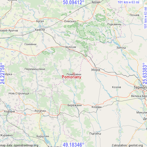
Pomoriany GPS coordinates[2]
49° 38' 27.312" North, 24° 55' 50.52" East
| Map corner | latitude | longitude |
|---|---|---|
| Upper-left | 50.09412°, | 24.22758° |
| Center: | 49.64092°, | 24.9307° |
| Lower-right: | 49.18346°, | 25.63383° |
| Map W x H: | 101.3×101.3 km | = 62.9×62.9mi |
| max Lat: | 52.18903° ⇑23.3% North |
| Pomoriany: | 49.64092° |
| min Lat: | ⇓76.7% South 44.39214° |
| min Long | Pomoriany | max Long |
| 22.20555° | 24.9307° | 40.13222° |
| W 13.6%⇐ | ⇒86.4% E |
Elevation
Elevation of Pomoriany is 323 m = 1060 ft, and this is 167.2 m = 549 ft above average elevation for this country.
| Max E: |
886 m = 2907 ft | 7.8% |
| Pomoriany | 323 m 1060 ft | |
| Avg. | 155.8 m = 511 ft | |
Min E: |
-3 m = -10 ft | 92.2% |
See also: Ukraine elevation on elevation.city.
Geographical zone
Pomoriany is located in North temperate zone (between Tropic of Cancer and the Arctic Circle). Distance of this North polar circle is 1881.6 km =1169.2 mi to North.| Distance of | km | miles | from Pomoriany |
|---|---|---|---|
| North Pole | 4487.5 | 2788.4 | to North |
| Arctic Circle | 1881.6 | 1169.2 | to North |
| Tropic Cancer | 2913.6 | 1810.4 | to South |
| Equator | 5519.6 | 3429.7 | to South |


Nearby cities:
15 places around Pomoriany: (largest is in red/bold)
• Chesniki
31.7 km =19.7 mi,  207°
207°
• Dunayiv
8.1 km =5 mi,  250°
250°
• Kozova
27.8 km =17.3 mi,  145°
145°
• Nadrichne
12.1 km =7.5 mi,  170°
170°
• Olesko
35.8 km =22.2 mi,  355°
355°
• Ozerna
28.7 km =17.8 mi,  92°
92°
• Peremyshlyany
26.9 km =16.7 mi,  275°
275°
• Pidhirtsi
34.1 km =21.2 mi,  5°
5°
• Ray
23.1 km =14.4 mi,  183°
183°
• Rohatyn
34.7 km =21.6 mi,  221°
221°
• Svirzh
35.4 km =22 mi,  271°
271°
• Vyshnivchyk
14.9 km =9.3 mi,  296°
296°
• Zboriv
15.4 km =9.6 mi,  80°
80°
• Zolochiv
18.5 km =11.5 mi,  351°
351°
• Бережани
21.2 km =13.2 mi, 179°
Sources, notices
• [Note1] Compared only with cities in Ukraine existing in our database
• [Src1] Map data: © OpenStreetMap contributors (CC-BY-SA)
• [Src2] Other city data from geonames.org with taken over terms of usage.
• [Src3] Geographical zone / Annual Mean Temperature by Robert A. Rohde @ Wikipedia
