Zboriv geodata
Zboriv (Ternopil) is a seat of a second-order administrative division; located in Ukraine in Europe/Kiev (GMT+3) time zone. With population of 7,159 people, there are 498 cities with bigger population in this country. Compared to other cities in Ukraine, 77.3% of cities are located further ↓South; 85.5% of cities are located further →East and 94.5% of cities have lower elevation than Zboriv. Note1


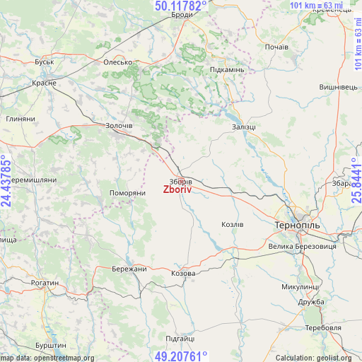
Zboriv GPS coordinates[2]
49° 39' 53.424" North, 25° 8' 27.492" East
| Map corner | latitude | longitude |
|---|---|---|
| Upper-left | 50.11782°, | 24.43785° |
| Center: | 49.66484°, | 25.14097° |
| Lower-right: | 49.20761°, | 25.8441° |
| Map W x H: | 101.2×101.2 km | = 62.9×62.9mi |
| max Lat: | 52.18903° ⇑22.7% North |
| Zboriv: | 49.66484° |
| min Lat: | ⇓77.3% South 44.39214° |
| min Long | Zboriv | max Long |
| 22.20555° | 25.14097° | 40.13222° |
| W 14.5%⇐ | ⇒85.5% E |
Elevation
Elevation of Zboriv is 354 m = 1161 ft, and this is 198.2 m = 650 ft above average elevation for this country.
| Max E: |
886 m = 2907 ft | 5.5% |
| Zboriv | 354 m 1161 ft | |
| Avg. | 155.8 m = 511 ft | |
Min E: |
-3 m = -10 ft | 94.5% |
See also: Ukraine elevation on elevation.city.
Geographical zone
Zboriv is located in North temperate zone (between Tropic of Cancer and the Arctic Circle). Distance of this North polar circle is 1879 km =1167.6 mi to North.| Distance of | km | miles | from Zboriv |
|---|---|---|---|
| North Pole | 4484.8 | 2786.7 | to North |
| Arctic Circle | 1879 | 1167.6 | to North |
| Tropic Cancer | 2916.3 | 1812.1 | to South |
| Equator | 5522.2 | 3431.3 | to South |


Nearby cities:
15 places around Zboriv: (largest is in red/bold)
• Dunayiv
23.4 km =14.5 mi,  256°
256°
• Kozova
25.5 km =15.8 mi,  178°
178°
• Nadrichne
19.6 km =12.2 mi,  221°
221°
• Olesko
37.5 km =23.3 mi,  331°
331°
• Ozerna
14.1 km =8.8 mi,  106°
106°
• Petrikov
34.9 km =21.7 mi,  115°
115°
• Pidhirtsi
33.4 km =20.8 mi,  339°
339°
• Pidkamin’
33.7 km =20.9 mi,  21°
21°
• Pomoriany
15.4 km =9.6 mi, 260°
• Ray
30.7 km =19.1 mi,  213°
213°
• Ternopil
34.6 km =21.5 mi, 110°
• Vyshnivchyk
28.7 km =17.8 mi,  277°
277°
• Zaliztsi
21.9 km =13.6 mi,  49°
49°
• Zolochiv
23.7 km =14.7 mi,  311°
311°
• Бережани
28.2 km =17.5 mi, 212°
Sources, notices
• [Note1] Compared only with cities in Ukraine existing in our database
• [Src1] Map data: © OpenStreetMap contributors (CC-BY-SA)
• [Src2] Other city data from geonames.org with taken over terms of usage.
• [Src3] Geographical zone / Annual Mean Temperature by Robert A. Rohde @ Wikipedia
