Bilshivtsi geodata
Bilshivtsi (Ivano-Frankivsk) is a populated place; located in Ukraine in Europe/Kiev (GMT+3) time zone. With population of 2,500 people, there are 1035 cities with bigger population in this country. Compared to other cities in Ukraine, 69.6% of cities are located further ↓South; 87.5% of cities are located further →East and 73.7% of cities have lower elevation than Bilshivtsi. Note1


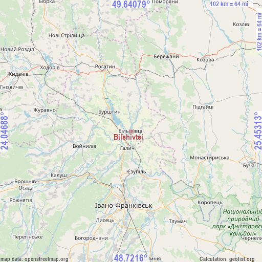
Bilshivtsi GPS coordinates[2]
49° 10' 59.988" North, 24° 45' 0" East
| Map corner | latitude | longitude |
|---|---|---|
| Upper-left | 49.64079°, | 24.04688° |
| Center: | 49.18333°, | 24.75° |
| Lower-right: | 48.7216°, | 25.45313° |
| Map W x H: | 102.2×102.2 km | = 63.5×63.5mi |
| max Lat: | 52.18903° ⇑30.4% North |
| Bilshivtsi: | 49.18333° |
| min Lat: | ⇓69.6% South 44.39214° |
| min Long | Bilshivtsi | max Long |
| 22.20555° | 24.75° | 40.13222° |
| W 12.5%⇐ | ⇒87.5% E |
Elevation
Elevation of Bilshivtsi is 219 m = 719 ft, and this is 63.2 m = 207 ft above average elevation for this country.
| Max E: |
886 m = 2907 ft | 26.3% |
| Bilshivtsi | 219 m 719 ft | |
| Avg. | 155.8 m = 511 ft | |
Min E: |
-3 m = -10 ft | 73.7% |
See also: Ukraine elevation on elevation.city.
Geographical zone
Bilshivtsi is located in North temperate zone (between Tropic of Cancer and the Arctic Circle). Distance of this North polar circle is 1932.5 km =1200.8 mi to North.| Distance of | km | miles | from Bilshivtsi |
|---|---|---|---|
| North Pole | 4538.4 | 2820 | to North |
| Arctic Circle | 1932.5 | 1200.8 | to North |
| Tropic Cancer | 2862.8 | 1778.9 | to South |
| Equator | 5468.7 | 3398.1 | to South |


Nearby cities:
15 places around Bilshivtsi: (largest is in red/bold)
• Burshtyn
12.2 km =7.6 mi,  313°
313°
• Cherniyiv
36.4 km =22.6 mi,  184°
184°
• Chesniki
22.8 km =14.2 mi,  355°
355°
• Halych
7.1 km =4.4 mi,  194°
194°
• Ivano-Frankivsk
29.3 km =18.2 mi, 185°
• Kalush
33.4 km =20.8 mi,  235°
235°
• Monastyrys’ka
32.5 km =20.2 mi,  108°
108°
• Pidhaytsi
29.4 km =18.3 mi,  71°
71°
• Ray
30.1 km =18.7 mi,  22°
22°
• Rohatyn
27.1 km =16.8 mi,  337°
337°
• Tysmenytsya
32 km =19.9 mi,  167°
167°
• Uhryniv
25.7 km =16 mi, 189°
• Yamnytsya
21.7 km =13.5 mi, 188°
• Zahvizdya
30.3 km =18.8 mi, 193°
• Бережани
32.5 km =20.2 mi, 24°
Sources, notices
• [Note1] Compared only with cities in Ukraine existing in our database
• [Src1] Map data: © OpenStreetMap contributors (CC-BY-SA)
• [Src2] Other city data from geonames.org with taken over terms of usage.
• [Src3] Geographical zone / Annual Mean Temperature by Robert A. Rohde @ Wikipedia
