Ordzhonikidze geodata
Ordzhonikidze (Republic of Crimea) is a populated place; located in Ukraine in Europe/Zaporozhye (GMT+3) time zone. With population of 2,572 people, there are 1021 cities with bigger population in this country. Compared to other cities in Ukraine, 92.1% of cities are located further ↑North; 83.8% of cities are located further ←West and 90.1% of cities have higher elevation than Ordzhonikidze. Note1


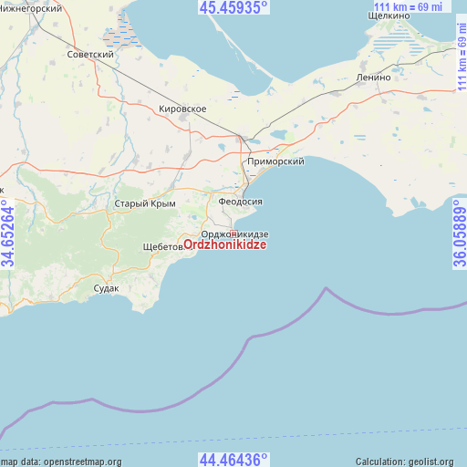
Ordzhonikidze GPS coordinates[2]
44° 57' 50.436" North, 35° 21' 20.736" East
| Map corner | latitude | longitude |
|---|---|---|
| Upper-left | 45.45935°, | 34.65264° |
| Center: | 44.96401°, | 35.35576° |
| Lower-right: | 44.46436°, | 36.05889° |
| Map W x H: | 110.6×110.6 km | = 68.7×68.7mi |
| max Lat: | 52.18903° ⇑92.1% North |
| Ordzhonikidze: | 44.96401° |
| min Lat: | ⇓7.9% South 44.39214° |
| min Long | Ordzhonikidze | max Long |
| 22.20555° | 35.35576° | 40.13222° |
| W 83.8%⇐ | ⇒16.2% E |
Elevation
Elevation of Ordzhonikidze is 19 m = 62 ft, and this is 136.8 m = 449 ft below average elevation for this country.
| Max E: |
886 m = 2907 ft | 90.1% |
| Avg. | 155.8 m = 511 ft | |
| Ordzhonikidze | 19 m = 62 ft | |
Min E: |
-3 m = -10 ft | 9.9% |
See also: Ukraine elevation on elevation.city.
Geographical zone
Ordzhonikidze is located in North temperate zone (between Tropic of Cancer and the Arctic Circle). Distance of this Northern Tropic circle is 2393.6 km =1487.3 mi to South.| Distance of | km | miles | from Ordzhonikidze |
|---|---|---|---|
| North Pole | 5007.5 | 3111.5 | to North |
| Arctic Circle | 2401.6 | 1492.3 | to North |
| Tropic Cancer | 2393.6 | 1487.3 | to South |
| Equator | 4999.5 | 3106.5 | to South |


Nearby cities:
15 places around Ordzhonikidze: (largest is in red/bold)
• Beregovoye
15.8 km =9.8 mi,  22°
22°
• Blizhneye
10.5 km =6.5 mi,  349°
349°
• Feodosiya
8.3 km =5.2 mi,  12°
12°
• Izyumovka
19.4 km =12.1 mi,  297°
297°
• Koktebel
8.6 km =5.3 mi,  268°
268°
• Krasnokamenka
22.5 km =14 mi,  258°
258°
• Nasypnoe
11 km =6.8 mi,  333°
333°
• Pervomayskoye
18.6 km =11.6 mi,  305°
305°
• Primorskiy
19.8 km =12.3 mi,  29°
29°
• Shchebetovka
15.8 km =9.8 mi, 259°
• Solnechnaya Dolina
22.2 km =13.8 mi,  242°
242°
• Solnechnoye
9.3 km =5.8 mi, 354°
• Stary Krym
22 km =13.7 mi,  289°
289°
• Vladislavovka
22.8 km =14.2 mi,  4°
4°
• Zhuravki
21.2 km =13.2 mi, 328°
Sources, notices
• [Note1] Compared only with cities in Ukraine existing in our database
• [Src1] Map data: © OpenStreetMap contributors (CC-BY-SA)
• [Src2] Other city data from geonames.org with taken over terms of usage.
• [Src3] Geographical zone / Annual Mean Temperature by Robert A. Rohde @ Wikipedia
