Prymors’k geodata
Prymors’k (Zaporizhia) is a seat of a second-order administrative division; located in Ukraine in Europe/Zaporozhye (GMT+3) time zone. With population of 13,900 people, there are 272 cities with bigger population in this country. Compared to other cities in Ukraine, 65.5% of cities are located further ↑North; 89% of cities are located further ←West and 94.4% of cities have higher elevation than Prymors’k. Note1
Administrative division(s):
- Level 1: Zaporizhia
- Level 2: Prymorsk Raion
- Level 3: Prymorsk Urban United Territorial Community


Prymors’k GPS coordinates[2]
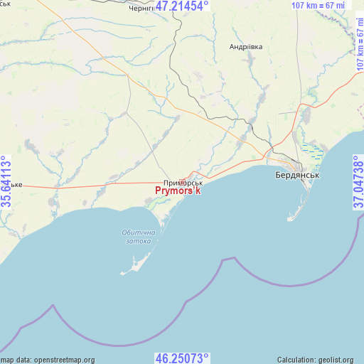
46° 44' 5.244" North, 36° 20' 39.3" East
| Map corner | latitude | longitude |
|---|---|---|
| Upper-left | 47.21454°, | 35.64113° |
| Center: | 46.73479°, | 36.34425° |
| Lower-right: | 46.25073°, | 37.04738° |
| Map W x H: | 107.2×107.2 km | = 66.6×66.6mi |
| max Lat: | 52.18903° ⇑65.5% North |
| Prymors’k: | 46.73479° |
| min Lat: | ⇓34.5% South 44.39214° |
| min Long | Prymors’k | max Long |
| 22.20555° | 36.34425° | 40.13222° |
| W 89%⇐ | ⇒11% E |
Elevation
Elevation of Prymors’k is 13 m = 43 ft, and this is 142.8 m = 469 ft below average elevation for this country.
| Max E: |
886 m = 2907 ft | 94.4% |
| Avg. | 155.8 m = 511 ft | |
| Prymors’k | 13 m = 43 ft | |
Min E: |
-3 m = -10 ft | 5.6% |
See also: Ukraine elevation on elevation.city.
Geographical zone
Prymors’k is located in North temperate zone (between Tropic of Cancer and the Arctic Circle). Distance of this North polar circle is 2204.8 km =1370 mi to North.| Distance of | km | miles | from Prymors’k |
|---|---|---|---|
| North Pole | 4810.6 | 2989.2 | to North |
| Arctic Circle | 2204.8 | 1370 | to North |
| Tropic Cancer | 2590.5 | 1609.7 | to South |
| Equator | 5196.4 | 3228.9 | to South |


Nearby cities:
15 places around Prymors’k: (largest is in red/bold)
• Berdyansk
34.8 km =21.6 mi,  84°
84°
• Chernihivka
53.5 km =33.2 mi,  344°
344°
• Komysh-Zorya
71 km =44.1 mi,  21°
21°
• Kostyantynivka
70.8 km =44 mi,  277°
277°
• Kuybysheve
73 km =45.4 mi, 18°
• Melitopol
75.6 km =47 mi, 279°
• Novovasylivka
46.4 km =28.8 mi, 283°
• Osypenko
41.6 km =25.8 mi,  61°
61°
• Pryazovs’ke
53.5 km =33.2 mi,  269°
269°
• Rozivka
49.1 km =30.5 mi,  297°
297°
• Terpinnya
74.9 km =46.5 mi,  290°
290°
• Tokmak
75.1 km =46.7 mi,  320°
320°
• Urzuf
60.9 km =37.8 mi,  70°
70°
• Voznesenka
68.7 km =42.7 mi, 282°
• Yalta
75.1 km =46.7 mi, 70°
Sources, notices
• [Note1] Compared only with cities in Ukraine existing in our database
• [Src1] Map data: © OpenStreetMap contributors (CC-BY-SA)
• [Src2] Other city data from geonames.org with taken over terms of usage.
• [Src3] Geographical zone / Annual Mean Temperature by Robert A. Rohde @ Wikipedia
