Kuybysheve geodata
Kuybysheve (Zaporizhia) is a seat of a second-order administrative division; located in Ukraine in Europe/Zaporozhye (GMT+3) time zone. With population of 7,832 people, there are 456 cities with bigger population in this country. Compared to other cities in Ukraine, 61.6% of cities are located further ↑North; 90.1% of cities are located further ←West and 68.9% of cities have lower elevation than Kuybysheve. Note1


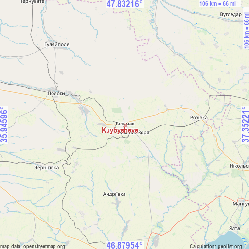
Kuybysheve GPS coordinates[2]
47° 21' 28.8" North, 36° 38' 56.688" East
| Map corner | latitude | longitude |
|---|---|---|
| Upper-left | 47.83216°, | 35.94596° |
| Center: | 47.358°, | 36.64908° |
| Lower-right: | 46.87954°, | 37.35221° |
| Map W x H: | 105.9×105.9 km | = 65.8×65.8mi |
| max Lat: | 52.18903° ⇑61.6% North |
| Kuybysheve: | 47.358° |
| min Lat: | ⇓38.4% South 44.39214° |
| min Long | Kuybysheve | max Long |
| 22.20555° | 36.64908° | 40.13222° |
| W 90.1%⇐ | ⇒9.9% E |
Elevation
Elevation of Kuybysheve is 201 m = 659 ft, and this is 45.2 m = 148 ft above average elevation for this country.
| Max E: |
886 m = 2907 ft | 31.1% |
| Kuybysheve | 201 m 659 ft | |
| Avg. | 155.8 m = 511 ft | |
Min E: |
-3 m = -10 ft | 68.9% |
See also: Ukraine elevation on elevation.city.
Geographical zone
Kuybysheve is located in North temperate zone (between Tropic of Cancer and the Arctic Circle). Distance of this North polar circle is 2135.5 km =1326.9 mi to North.| Distance of | km | miles | from Kuybysheve |
|---|---|---|---|
| North Pole | 4741.3 | 2946.1 | to North |
| Arctic Circle | 2135.5 | 1326.9 | to North |
| Tropic Cancer | 2659.8 | 1652.7 | to South |
| Equator | 5265.7 | 3272 | to South |


Nearby cities:
15 places around Kuybysheve: (largest is in red/bold)
• Chapayevka
26.1 km =16.2 mi,  298°
298°
• Chernihivka
40.8 km =25.4 mi,  244°
244°
• Dianivka
56.8 km =35.3 mi,  82°
82°
• Hulyaypole
45 km =28 mi,  319°
319°
• Komysh-Zorya
4.7 km =2.9 mi,  135°
135°
• Mala Tokmachka
60.2 km =37.4 mi,  289°
289°
• Manhush
60.2 km =37.4 mi,  123°
123°
• Nikol's’ke
53.5 km =33.2 mi,  108°
108°
• Osypenko
51.2 km =31.8 mi,  164°
164°
• Polohy
32.9 km =20.4 mi, 295°
• Rozivka
31.7 km =19.7 mi, 84°
• Temriuk
26.9 km =16.7 mi, 111°
• Urzuf
59.8 km =37.2 mi,  145°
145°
• Velyka Novosilka
56 km =34.8 mi,  14°
14°
• Zaliznychne
48.9 km =30.4 mi,  312°
312°
Sources, notices
• [Note1] Compared only with cities in Ukraine existing in our database
• [Src1] Map data: © OpenStreetMap contributors (CC-BY-SA)
• [Src2] Other city data from geonames.org with taken over terms of usage.
• [Src3] Geographical zone / Annual Mean Temperature by Robert A. Rohde @ Wikipedia
