Tokmak geodata
Tokmak (Zaporizhia) is a seat of a second-order administrative division; located in Ukraine in Europe/Zaporozhye (GMT+3) time zone. With population of 34,926 people, there are 127 cities with bigger population in this country. Compared to other cities in Ukraine, 62.3% of cities are located further ↑North; 85.2% of cities are located further ←West and 78.7% of cities have higher elevation than Tokmak. Note1


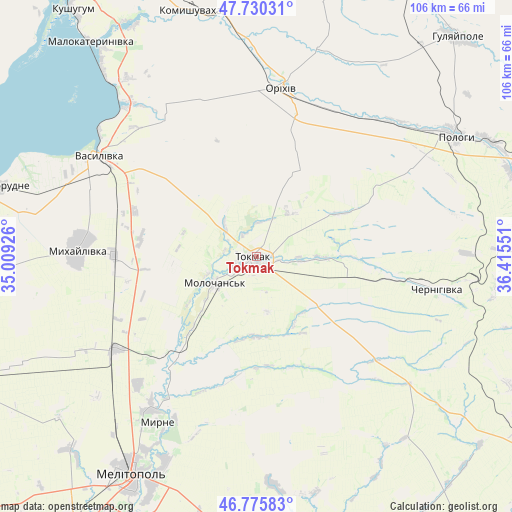
Tokmak GPS coordinates[2]
47° 15' 18.792" North, 35° 42' 44.568" East
| Map corner | latitude | longitude |
|---|---|---|
| Upper-left | 47.73031°, | 35.00926° |
| Center: | 47.25522°, | 35.71238° |
| Lower-right: | 46.77583°, | 36.41551° |
| Map W x H: | 106.1×106.1 km | = 65.9×65.9mi |
| max Lat: | 52.18903° ⇑62.3% North |
| Tokmak: | 47.25522° |
| min Lat: | ⇓37.7% South 44.39214° |
| min Long | Tokmak | max Long |
| 22.20555° | 35.71238° | 40.13222° |
| W 85.2%⇐ | ⇒14.8% E |
Elevation
Elevation of Tokmak is 48 m = 157 ft, and this is 107.8 m = 354 ft below average elevation for this country.
| Max E: |
886 m = 2907 ft | 78.7% |
| Avg. | 155.8 m = 511 ft | |
| Tokmak | 48 m = 157 ft | |
Min E: |
-3 m = -10 ft | 21.3% |
See also: Ukraine elevation on elevation.city.
Geographical zone
Tokmak is located in North temperate zone (between Tropic of Cancer and the Arctic Circle). Distance of this North polar circle is 2146.9 km =1334 mi to North.| Distance of | km | miles | from Tokmak |
|---|---|---|---|
| North Pole | 4752.8 | 2953.3 | to North |
| Arctic Circle | 2146.9 | 1334 | to North |
| Tropic Cancer | 2648.4 | 1645.6 | to South |
| Equator | 5254.3 | 3264.9 | to South |


Nearby cities:
15 places around Tokmak: (largest is in red/bold)
• Chernihivka
34.5 km =21.4 mi,  100°
100°
• Kirove
44.3 km =27.5 mi,  358°
358°
• Mala Tokmachka
34 km =21.1 mi,  23°
23°
• Matviyivka
47.4 km =29.5 mi,  244°
244°
• Mykhaylivka
37 km =23 mi,  272°
272°
• Novobohdanivka
34.6 km =21.5 mi, 236°
• Novovasylivka
47.3 km =29.4 mi,  176°
176°
• Orikhiv
35.1 km =21.8 mi,  9°
9°
• Preobrazhenka
36.1 km =22.4 mi, 12°
• Pryshyb
29.6 km =18.4 mi, 270°
• Rozivka
35.4 km =22 mi,  172°
172°
• Terpinnya
38.7 km =24 mi,  214°
214°
• Tymoshivka
45.7 km =28.4 mi,  260°
260°
• Vasylivka
38.7 km =24 mi,  301°
301°
• Voznesenka
46.6 km =29 mi,  203°
203°
Sources, notices
• [Note1] Compared only with cities in Ukraine existing in our database
• [Src1] Map data: © OpenStreetMap contributors (CC-BY-SA)
• [Src2] Other city data from geonames.org with taken over terms of usage.
• [Src3] Geographical zone / Annual Mean Temperature by Robert A. Rohde @ Wikipedia
