Chernihivka geodata
Chernihivka (Zaporizhia) is a seat of a second-order administrative division; located in Ukraine in Europe/Zaporozhye (GMT+3) time zone. In our database, there are 1661 cities with bigger population. Compared to other cities in Ukraine, 62.6% of cities are located further ↑North; 87.8% of cities are located further ←West and 60.3% of cities have higher elevation than Chernihivka. Note1


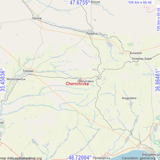
Chernihivka GPS coordinates[2]
47° 11' 59.712" North, 36° 9' 41.328" East
| Map corner | latitude | longitude |
|---|---|---|
| Upper-left | 47.6755°, | 35.45836° |
| Center: | 47.19992°, | 36.16148° |
| Lower-right: | 46.72004°, | 36.86461° |
| Map W x H: | 106.2×106.2 km | = 66×66mi |
| max Lat: | 52.18903° ⇑62.6% North |
| Chernihivka: | 47.19992° |
| min Lat: | ⇓37.4% South 44.39214° |
| min Long | Chernihivka | max Long |
| 22.20555° | 36.16148° | 40.13222° |
| W 87.8%⇐ | ⇒12.2% E |
Elevation
Elevation of Chernihivka is 105 m = 344 ft, and this is 50.8 m = 167 ft below average elevation for this country.
| Max E: |
886 m = 2907 ft | 60.3% |
| Avg. | 155.8 m = 511 ft | |
| Chernihivka | 105 m = 344 ft | |
Min E: |
-3 m = -10 ft | 39.7% |
See also: Ukraine elevation on elevation.city.
Geographical zone
Chernihivka is located in North temperate zone (between Tropic of Cancer and the Arctic Circle). Distance of this North polar circle is 2153 km =1337.8 mi to North.| Distance of | km | miles | from Chernihivka |
|---|---|---|---|
| North Pole | 4758.9 | 2957 | to North |
| Arctic Circle | 2153 | 1337.8 | to North |
| Tropic Cancer | 2642.2 | 1641.8 | to South |
| Equator | 5248.1 | 3261 | to South |


Nearby cities:
15 places around Chernihivka: (largest is in red/bold)
• Chapayevka
33.2 km =20.6 mi,  24°
24°
• Hulyaypole
52.1 km =32.4 mi,  7°
7°
• Kirove
61.4 km =38.2 mi,  325°
325°
• Komysh-Zorya
42.5 km =26.4 mi,  70°
70°
• Kuybysheve
40.8 km =25.4 mi,  64°
64°
• Mala Tokmachka
42.5 km =26.4 mi, 331°
• Novovasylivka
51.5 km =32 mi,  217°
217°
• Orikhiv
49.7 km =30.9 mi, 325°
• Osypenko
59.5 km =37 mi,  122°
122°
• Polohy
32.4 km =20.1 mi, 12°
• Preobrazhenka
48.8 km =30.3 mi, 327°
• Prymors’k
53.5 km =33.2 mi,  164°
164°
• Rozivka
41.3 km =25.7 mi,  225°
225°
• Tokmak
34.5 km =21.4 mi,  280°
280°
• Zaliznychne
50.3 km =31.3 mi,  0°
0°
Sources, notices
• [Note1] Compared only with cities in Ukraine existing in our database
• [Src1] Map data: © OpenStreetMap contributors (CC-BY-SA)
• [Src2] Other city data from geonames.org with taken over terms of usage.
• [Src3] Geographical zone / Annual Mean Temperature by Robert A. Rohde @ Wikipedia
