Pravda geodata
Pravda (Republic of Crimea) is a seat of a third-order administrative division; located in Ukraine in Europe/Simferopol (GMT+3) time zone. With population of 1,474 people, there are 1218 cities with bigger population in this country. Compared to other cities in Ukraine, 72.2% of cities are located further ↑North; 59% of cities are located further ←West and 90.9% of cities have higher elevation than Pravda. Note1
Administrative division(s):
- Level 1: Republic of Crimea
- Level 2: Pervomayskiy rayon
- Level 3: Pravdovskoye sel'skoye poselenye


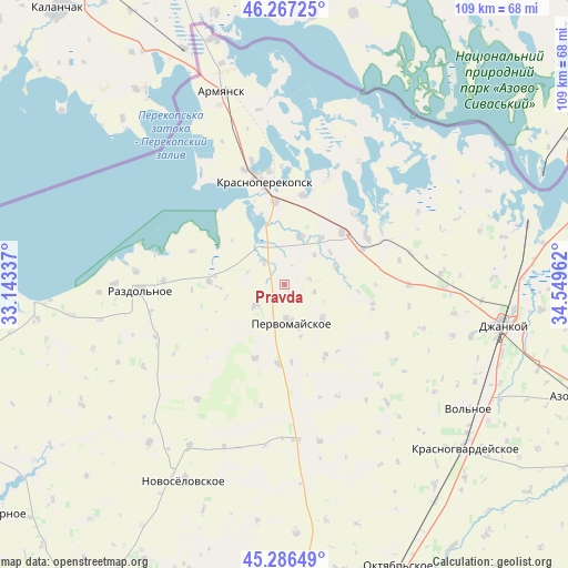
Pravda GPS coordinates[2]
45° 46' 44.508" North, 33° 50' 47.364" East
| Map corner | latitude | longitude |
|---|---|---|
| Upper-left | 46.26725°, | 33.14337° |
| Center: | 45.77903°, | 33.84649° |
| Lower-right: | 45.28649°, | 34.54962° |
| Map W x H: | 109.1×10⁹ km | = 67.8×67.7mi |
| max Lat: | 52.18903° ⇑72.2% North |
| Pravda: | 45.77903° |
| min Lat: | ⇓27.8% South 44.39214° |
| min Long | Pravda | max Long |
| 22.20555° | 33.84649° | 40.13222° |
| W 59%⇐ | ⇒41% E |
Elevation
Elevation of Pravda is 18 m = 59 ft, and this is 137.8 m = 452 ft below average elevation for this country.
| Max E: |
886 m = 2907 ft | 90.9% |
| Avg. | 155.8 m = 511 ft | |
| Pravda | 18 m = 59 ft | |
Min E: |
-3 m = -10 ft | 9.1% |
See also: Ukraine elevation on elevation.city.
Geographical zone
Pravda is located in North temperate zone (between Tropic of Cancer and the Arctic Circle). Distance of this North polar circle is 2311 km =1436 mi to North.| Distance of | km | miles | from Pravda |
|---|---|---|---|
| North Pole | 4916.9 | 3055.2 | to North |
| Arctic Circle | 2311 | 1436 | to North |
| Tropic Cancer | 2484.2 | 1543.6 | to South |
| Equator | 5090.2 | 3162.9 | to South |


Nearby cities:
15 places around Pravda: (largest is in red/bold)
• Bratskoye
8.3 km =5.2 mi,  44°
44°
• Dolinka
11.8 km =7.3 mi, 38°
• Grishino
15.3 km =9.5 mi,  184°
184°
• Ilyinka
5.9 km =3.7 mi,  317°
317°
• Ishun’
16.2 km =10.1 mi,  353°
353°
• Kalinino
6.8 km =4.2 mi,  233°
233°
• Krest’yanovka
9.5 km =5.9 mi,  131°
131°
• Novoivanovka
16.6 km =10.3 mi,  66°
66°
• Novopavlovka
10.3 km =6.4 mi,  19°
19°
• Oktyabr’skoye
15.9 km =9.9 mi,  149°
149°
• Orlovskoye
10.4 km =6.5 mi, 70°
• Pervomayskoye
6.9 km =4.3 mi,  173°
173°
• Ruch’i
14.4 km =8.9 mi,  272°
272°
• Stepnoye
15.2 km =9.4 mi,  201°
201°
• Voinka
15.1 km =9.4 mi,  48°
48°
Sources, notices
• [Note1] Compared only with cities in Ukraine existing in our database
• [Src1] Map data: © OpenStreetMap contributors (CC-BY-SA)
• [Src2] Other city data from geonames.org with taken over terms of usage.
• [Src3] Geographical zone / Annual Mean Temperature by Robert A. Rohde @ Wikipedia
