Krest’yanovka geodata
Krest’yanovka (Republic of Crimea) is a seat of a third-order administrative division; located in Ukraine in Europe/Simferopol (GMT+3) time zone. With population of 1,450 people, there are 1222 cities with bigger population in this country. Compared to other cities in Ukraine, 73.1% of cities are located further ↑North; 61% of cities are located further ←West and 85.5% of cities have higher elevation than Krest’yanovka. Note1
Administrative division(s):
- Level 1: Republic of Crimea
- Level 2: Pervomayskiy rayon
- Level 3: Krestyanovskoye sel'skoye poselenye


Krest’yanovka GPS coordinates[2]
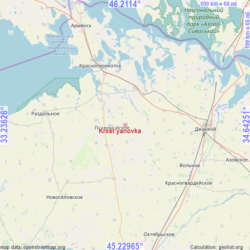
45° 43' 21.648" North, 33° 56' 21.768" East
| Map corner | latitude | longitude |
|---|---|---|
| Upper-left | 46.2114°, | 33.23626° |
| Center: | 45.72268°, | 33.93938° |
| Lower-right: | 45.22965°, | 34.64251° |
| Map W x H: | 109.2×109.2 km | = 67.9×67.9mi |
| max Lat: | 52.18903° ⇑73.1% North |
| Krest’yanovka: | 45.72268° |
| min Lat: | ⇓26.9% South 44.39214° |
| min Long | Krest’yanovka | max Long |
| 22.20555° | 33.93938° | 40.13222° |
| W 61%⇐ | ⇒39% E |
Elevation
Elevation of Krest’yanovka is 29 m = 95 ft, and this is 126.8 m = 416 ft below average elevation for this country.
| Max E: |
886 m = 2907 ft | 85.5% |
| Avg. | 155.8 m = 511 ft | |
| Krest’yanovka | 29 m = 95 ft | |
Min E: |
-3 m = -10 ft | 14.5% |
See also: Ukraine elevation on elevation.city.
Geographical zone
Krest’yanovka is located in North temperate zone (between Tropic of Cancer and the Arctic Circle). Distance of this North polar circle is 2317.3 km =1439.9 mi to North.| Distance of | km | miles | from Krest’yanovka |
|---|---|---|---|
| North Pole | 4923.2 | 3059.1 | to North |
| Arctic Circle | 2317.3 | 1439.9 | to North |
| Tropic Cancer | 2478 | 1539.8 | to South |
| Equator | 5083.9 | 3159 | to South |


Nearby cities:
15 places around Krest’yanovka: (largest is in red/bold)
• Abrikosovo
13 km =8.1 mi,  104°
104°
• Bratskoye
12.2 km =7.6 mi,  353°
353°
• Dolinka
15.5 km =9.6 mi,  0°
0°
• Grishino
12.3 km =7.6 mi,  223°
223°
• Hvardiiske
15.4 km =9.6 mi,  169°
169°
• Ilyinka
15.4 km =9.6 mi,  313°
313°
• Kalinino
12.8 km =8 mi,  279°
279°
• Novoivanovka
15.2 km =9.4 mi,  31°
31°
• Oktyabr’skoye
7.5 km =4.7 mi, 174°
• Orlovskoye
10.1 km =6.3 mi,  14°
14°
• Ostrovskoye
10.1 km =6.3 mi,  77°
77°
• Pervomayskoye
6.5 km =4 mi,  264°
264°
• Pravda
9.5 km =5.9 mi, 311°
• Roskoshnoye
15.8 km =9.8 mi,  119°
119°
• Stepnoye
15 km =9.3 mi,  238°
238°
Sources, notices
• [Note1] Compared only with cities in Ukraine existing in our database
• [Src1] Map data: © OpenStreetMap contributors (CC-BY-SA)
• [Src2] Other city data from geonames.org with taken over terms of usage.
• [Src3] Geographical zone / Annual Mean Temperature by Robert A. Rohde @ Wikipedia
