Dolinka geodata
Dolinka (Republic of Crimea) is a populated place; located in Ukraine in Europe/Simferopol (GMT+3) time zone. With population of 582 people, there are 1601 cities with bigger population in this country. Compared to other cities in Ukraine, 71.1% of cities are located further ↑North; 61% of cities are located further ←West and 98.6% of cities have higher elevation than Dolinka. Note1
Administrative division(s):
- Level 1: Republic of Crimea
- Level 2: Krasnoperekopsk Raion
- Level 3: Novopavlovskoye sel'skoye poselenye


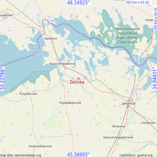
Dolinka GPS coordinates[2]
45° 51' 42.336" North, 33° 56' 27.528" East
| Map corner | latitude | longitude |
|---|---|---|
| Upper-left | 46.34925°, | 33.23786° |
| Center: | 45.86176°, | 33.94098° |
| Lower-right: | 45.36995°, | 34.64411° |
| Map W x H: | 108.9×108.9 km | = 67.7×67.7mi |
| max Lat: | 52.18903° ⇑71.1% North |
| Dolinka: | 45.86176° |
| min Lat: | ⇓28.9% South 44.39214° |
| min Long | Dolinka | max Long |
| 22.20555° | 33.94098° | 40.13222° |
| W 61%⇐ | ⇒39% E |
Elevation
Elevation of Dolinka is 6 m = 20 ft, and this is 149.8 m = 491 ft below average elevation for this country.
| Max E: |
886 m = 2907 ft | 98.6% |
| Avg. | 155.8 m = 511 ft | |
| Dolinka | 6 m = 20 ft | |
Min E: |
-3 m = -10 ft | 1.4% |
See also: Ukraine elevation on elevation.city.
Geographical zone
Dolinka is located in North temperate zone (between Tropic of Cancer and the Arctic Circle). Distance of this North polar circle is 2301.8 km =1430.3 mi to North.| Distance of | km | miles | from Dolinka |
|---|---|---|---|
| North Pole | 4907.7 | 3049.5 | to North |
| Arctic Circle | 2301.8 | 1430.3 | to North |
| Tropic Cancer | 2493.4 | 1549.3 | to South |
| Equator | 5099.3 | 3168.6 | to South |


Nearby cities:
15 places around Dolinka: (largest is in red/bold)
• Bratskoye
3.7 km =2.3 mi,  204°
204°
• Ilyinka
12.3 km =7.6 mi,  246°
246°
• Ishun’
11.4 km =7.1 mi,  307°
307°
• Istochnoye
8.2 km =5.1 mi,  53°
53°
• Krasnoarmeyskoye
15.9 km =9.9 mi,  25°
25°
• Krasnoperekops’k
15.4 km =9.6 mi, 313°
• Krest’yanovka
15.5 km =9.6 mi,  180°
180°
• Magazinka
8.4 km =5.2 mi,  88°
88°
• Novoivanovka
8.2 km =5.1 mi,  107°
107°
• Novopavlovka
4 km =2.5 mi,  277°
277°
• Orlovskoye
6.2 km =3.9 mi,  156°
156°
• Pravda
11.8 km =7.3 mi,  218°
218°
• Vishnyovka
10.9 km =6.8 mi,  4°
4°
• Voinka
4 km =2.5 mi,  76°
76°
• Zelyonaya Niva
9 km =5.6 mi,  334°
334°
Sources, notices
• [Note1] Compared only with cities in Ukraine existing in our database
• [Src1] Map data: © OpenStreetMap contributors (CC-BY-SA)
• [Src2] Other city data from geonames.org with taken over terms of usage.
• [Src3] Geographical zone / Annual Mean Temperature by Robert A. Rohde @ Wikipedia
