Oktyabr’skoye geodata
Oktyabr’skoye (Republic of Crimea) is a seat of a third-order administrative division; located in Ukraine in Europe/Simferopol (GMT+3) time zone. With population of 1,192 people, there are 1300 cities with bigger population in this country. Compared to other cities in Ukraine, 74.3% of cities are located further ↑North; 61.3% of cities are located further ←West and 78.4% of cities have higher elevation than Oktyabr’skoye. Note1
Administrative division(s):
- Level 1: Republic of Crimea
- Level 2: Pervomayskiy rayon
- Level 3: Oktyabr'skoye sel'skoye poselenye


Oktyabr’skoye GPS coordinates[2]
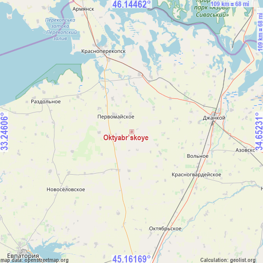
45° 39' 19.116" North, 33° 56' 57.048" East
| Map corner | latitude | longitude |
|---|---|---|
| Upper-left | 46.14462°, | 33.24606° |
| Center: | 45.65531°, | 33.94918° |
| Lower-right: | 45.16169°, | 34.65231° |
| Map W x H: | 109.3×109.3 km | = 67.9×67.9mi |
| max Lat: | 52.18903° ⇑74.3% North |
| Oktyabr’skoye: | 45.65531° |
| min Lat: | ⇓25.7% South 44.39214° |
| min Long | Oktyabr’skoye | max Long |
| 22.20555° | 33.94918° | 40.13222° |
| W 61.3%⇐ | ⇒38.7% E |
Elevation
Elevation of Oktyabr’skoye is 49 m = 161 ft, and this is 106.8 m = 350 ft below average elevation for this country.
| Max E: |
886 m = 2907 ft | 78.4% |
| Avg. | 155.8 m = 511 ft | |
| Oktyabr’skoye | 49 m = 161 ft | |
Min E: |
-3 m = -10 ft | 21.6% |
See also: Ukraine elevation on elevation.city.
Geographical zone
Oktyabr’skoye is located in North temperate zone (between Tropic of Cancer and the Arctic Circle). Distance of this North polar circle is 2324.8 km =1444.6 mi to North.| Distance of | km | miles | from Oktyabr’skoye |
|---|---|---|---|
| North Pole | 4930.7 | 3063.8 | to North |
| Arctic Circle | 2324.8 | 1444.6 | to North |
| Tropic Cancer | 2470.5 | 1535.1 | to South |
| Equator | 5076.4 | 3154.3 | to South |


Nearby cities:
15 places around Oktyabr’skoye: (largest is in red/bold)
• Abrikosovo
12.5 km =7.8 mi,  70°
70°
• Aleksandrovka
14.6 km =9.1 mi,  126°
126°
• Chernovo
16.4 km =10.2 mi,  184°
184°
• Grishino
9.3 km =5.8 mi,  260°
260°
• Hvardiiske
7.9 km =4.9 mi,  164°
164°
• Kalinino
16.5 km =10.3 mi,  305°
305°
• Krest’yanovka
7.5 km =4.7 mi,  354°
354°
• Ostrovskoye
13.3 km =8.3 mi,  43°
43°
• Pervomayskoye
10 km =6.2 mi, 313°
• Pravda
15.9 km =9.9 mi,  329°
329°
• Roskoshnoye
12.9 km =8 mi,  91°
91°
• Sary-Bash
15.7 km =9.8 mi,  233°
233°
• Stepnoye
13.6 km =8.5 mi,  268°
268°
• Voykovo
16.9 km =10.5 mi,  199°
199°
• Zernovoye
15.4 km =9.6 mi,  100°
100°
Sources, notices
• [Note1] Compared only with cities in Ukraine existing in our database
• [Src1] Map data: © OpenStreetMap contributors (CC-BY-SA)
• [Src2] Other city data from geonames.org with taken over terms of usage.
• [Src3] Geographical zone / Annual Mean Temperature by Robert A. Rohde @ Wikipedia
