Syevyerodonets’k geodata
Syevyerodonets’k (Luhansk) is a populated place; located in Ukraine in Europe/Zaporozhye (GMT+3) time zone. With population of 130,000 people, there are 36 cities with bigger population in this country. Compared to other cities in Ukraine, 65% of cities are located further ↓South; 96.7% of cities are located further ←West and 70.3% of cities have higher elevation than Syevyerodonets’k. Note1


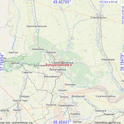
Syevyerodonets’k GPS coordinates[2]
48° 56' 53.952" North, 38° 29' 29.976" East
| Map corner | latitude | longitude |
|---|---|---|
| Upper-left | 49.40795°, | 37.78854° |
| Center: | 48.94832°, | 38.49166° |
| Lower-right: | 48.48441°, | 39.19479° |
| Map W x H: | 102.7×102.7 km | = 63.8×63.8mi |
| max Lat: | 52.18903° ⇑35% North |
| Syevyerodonets’k: | 48.94832° |
| min Lat: | ⇓65% South 44.39214° |
| min Long | Syevyerodonets� | max Long |
| 22.20555° | 38.49166° | 40.13222° |
| W 96.7%⇐ | ⇒3.3% E |
Elevation
Elevation of Syevyerodonets’k is 74 m = 243 ft, and this is 81.8 m = 268 ft below average elevation for this country.
| Max E: |
886 m = 2907 ft | 70.3% |
| Avg. | 155.8 m = 511 ft | |
| Syevyerodonets’k | 74 m = 243 ft | |
Min E: |
-3 m = -10 ft | 29.7% |
See also: Syevyerodonets’k elevation on elevation.city.
Geographical zone
Syevyerodonets’k is located in North temperate zone (between Tropic of Cancer and the Arctic Circle). Distance of this North polar circle is 1958.6 km =1217 mi to North.| Distance of | km | miles | from Syevyerodonets’k |
|---|---|---|---|
| North Pole | 4564.5 | 2836.2 | to North |
| Arctic Circle | 1958.6 | 1217 | to North |
| Tropic Cancer | 2836.6 | 1762.6 | to South |
| Equator | 5442.5 | 3381.8 | to South |


Nearby cities:
15 places around Syevyerodonets’k: (largest is in red/bold)
• Bilohorivka
18 km =11.2 mi,  261°
261°
• Hirs’ke
23.8 km =14.8 mi,  179°
179°
• Kirovs’k
36.3 km =22.6 mi,  162°
162°
• Kreminna
22.9 km =14.2 mi,  299°
299°
• Lysychans’k
6 km =3.7 mi,  216°
216°
• Met’olkine
4.9 km =3 mi,  113°
113°
• Novoaydar
37.6 km =23.4 mi,  87°
87°
• Pervomays’k
35.6 km =22.1 mi,  173°
173°
• Popasna
36 km =22.4 mi,  193°
193°
• Pryvillya
15.5 km =9.6 mi, 298°
• Rubizhne
10.8 km =6.7 mi,  311°
311°
• Serebryanka
26.3 km =16.3 mi, 262°
• Sivers’k
30 km =18.6 mi,  252°
252°
• Toshkivka
19.9 km =12.4 mi, 161°
• Voronove
8.2 km =5.1 mi,  133°
133°
Sources, notices
• [Note1] Compared only with cities in Ukraine existing in our database
• [Src1] Map data: © OpenStreetMap contributors (CC-BY-SA)
• [Src2] Other city data from geonames.org with taken over terms of usage.
• [Src3] Geographical zone / Annual Mean Temperature by Robert A. Rohde @ Wikipedia
