Voronove geodata
Voronove (Luhansk) is a populated place; located in Ukraine in Europe/Zaporozhye (GMT+3) time zone. With population of 735 people, there are 1519 cities with bigger population in this country. Compared to other cities in Ukraine, 63.8% of cities are located further ↓South; 97% of cities are located further ←West and 69.2% of cities have higher elevation than Voronove. Note1


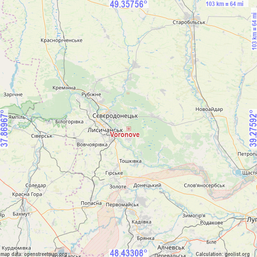
Voronove GPS coordinates[2]
48° 53' 50.856" North, 38° 34' 22.044" East
| Map corner | latitude | longitude |
|---|---|---|
| Upper-left | 49.35756°, | 37.86967° |
| Center: | 48.89746°, | 38.57279° |
| Lower-right: | 48.43308°, | 39.27592° |
| Map W x H: | 102.8×102.8 km | = 63.9×63.9mi |
| max Lat: | 52.18903° ⇑36.2% North |
| Voronove: | 48.89746° |
| min Lat: | ⇓63.8% South 44.39214° |
| min Long | Voronove | max Long |
| 22.20555° | 38.57279° | 40.13222° |
| W 97%⇐ | ⇒3% E |
Elevation
Elevation of Voronove is 77 m = 253 ft, and this is 78.8 m = 259 ft below average elevation for this country.
| Max E: |
886 m = 2907 ft | 69.2% |
| Avg. | 155.8 m = 511 ft | |
| Voronove | 77 m = 253 ft | |
Min E: |
-3 m = -10 ft | 30.8% |
See also: Ukraine elevation on elevation.city.
Geographical zone
Voronove is located in North temperate zone (between Tropic of Cancer and the Arctic Circle). Distance of this North polar circle is 1964.3 km =1220.6 mi to North.| Distance of | km | miles | from Voronove |
|---|---|---|---|
| North Pole | 4570.2 | 2839.8 | to North |
| Arctic Circle | 1964.3 | 1220.6 | to North |
| Tropic Cancer | 2831 | 1759.1 | to South |
| Equator | 5436.9 | 3378.3 | to South |


Nearby cities:
15 places around Voronove: (largest is in red/bold)
• Bilohorivka
23.9 km =14.9 mi,  277°
277°
• Hirs’ke
19 km =11.8 mi,  197°
197°
• Kirovs’k
29.4 km =18.3 mi,  169°
169°
• Kreminna
30.9 km =19.2 mi,  303°
303°
• Lysychans’k
9.6 km =6 mi,  274°
274°
• Met’olkine
3.9 km =2.4 mi,  339°
339°
• Novoaydar
32.5 km =20.2 mi,  76°
76°
• Pervomays’k
29.8 km =18.5 mi,  183°
183°
• Popasna
32.7 km =20.3 mi,  205°
205°
• Pryvillya
23.5 km =14.6 mi, 303°
• Rubizhne
19 km =11.8 mi,  312°
312°
• Serebryanka
32.1 km =19.9 mi, 274°
• Syevyerodonets’k
8.2 km =5.1 mi, 313°
• Toshkivka
13.2 km =8.2 mi, 178°
• Tr’okhizbenka
32.5 km =20.2 mi,  118°
118°
Sources, notices
• [Note1] Compared only with cities in Ukraine existing in our database
• [Src1] Map data: © OpenStreetMap contributors (CC-BY-SA)
• [Src2] Other city data from geonames.org with taken over terms of usage.
• [Src3] Geographical zone / Annual Mean Temperature by Robert A. Rohde @ Wikipedia
