Shevchenkove geodata
Shevchenkove (Mykolaiv) is a populated place; located in Ukraine in Europe/Kiev (GMT+3) time zone. With population of 3,031 people, there are 936 cities with bigger population in this country. Compared to other cities in Ukraine, 64.5% of cities are located further ↑North; 56.6% of cities are located further →East and 79.8% of cities have higher elevation than Shevchenkove. Note1


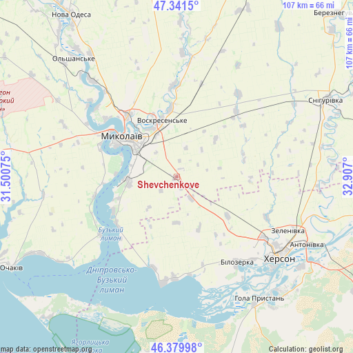
Shevchenkove GPS coordinates[2]
46° 51' 46.404" North, 32° 12' 13.932" East
| Map corner | latitude | longitude |
|---|---|---|
| Upper-left | 47.3415°, | 31.50075° |
| Center: | 46.86289°, | 32.20387° |
| Lower-right: | 46.37998°, | 32.907° |
| Map W x H: | 106.9×106.9 km | = 66.4×66.4mi |
| max Lat: | 52.18903° ⇑64.5% North |
| Shevchenkove: | 46.86289° |
| min Lat: | ⇓35.5% South 44.39214° |
| min Long | Shevchenkove | max Long |
| 22.20555° | 32.20387° | 40.13222° |
| W 43.4%⇐ | ⇒56.6% E |
Elevation
Elevation of Shevchenkove is 44 m = 144 ft, and this is 111.8 m = 367 ft below average elevation for this country.
| Max E: |
886 m = 2907 ft | 79.8% |
| Avg. | 155.8 m = 511 ft | |
| Shevchenkove | 44 m = 144 ft | |
Min E: |
-3 m = -10 ft | 20.2% |
See also: Ukraine elevation on elevation.city.
Geographical zone
Shevchenkove is located in North temperate zone (between Tropic of Cancer and the Arctic Circle). Distance of this North polar circle is 2190.5 km =1361.1 mi to North.| Distance of | km | miles | from Shevchenkove |
|---|---|---|---|
| North Pole | 4796.4 | 2980.3 | to North |
| Arctic Circle | 2190.5 | 1361.1 | to North |
| Tropic Cancer | 2604.7 | 1618.5 | to South |
| Equator | 5210.7 | 3237.8 | to South |


Nearby cities:
15 places around Shevchenkove: (largest is in red/bold)
• Bilozerka
32.1 km =19.9 mi,  145°
145°
• Chornobayivka
32.6 km =20.3 mi,  125°
125°
• Chulakivka
57.3 km =35.6 mi,  168°
168°
• Hola Prystan’
44.6 km =27.7 mi, 146°
• Kherson
39 km =24.2 mi, 126°
• Komyshany
34.1 km =21.2 mi,  137°
137°
• Mykolayiv
19.4 km =12.1 mi,  306°
306°
• Ochakiv
57.1 km =35.5 mi,  240°
240°
• Ol'shanskoye
47.3 km =29.4 mi,  318°
318°
• Oleksandrivka
42.5 km =26.4 mi,  93°
93°
• Parutyne
29.2 km =18.1 mi,  233°
233°
• Snihurivka
51.4 km =31.9 mi,  62°
62°
• Stanislav
32.9 km =20.4 mi,  187°
187°
• Tsyurupyns’k
47.7 km =29.6 mi,  124°
124°
• Геройское
45.9 km =28.5 mi,  211°
211°
Sources, notices
• [Note1] Compared only with cities in Ukraine existing in our database
• [Src1] Map data: © OpenStreetMap contributors (CC-BY-SA)
• [Src2] Other city data from geonames.org with taken over terms of usage.
• [Src3] Geographical zone / Annual Mean Temperature by Robert A. Rohde @ Wikipedia
