Borodianka geodata
Borodianka (Kyiv) is a seat of a second-order administrative division; located in Ukraine in Europe/Kiev (GMT+3) time zone. With population of 12,069 people, there are 309 cities with bigger population in this country. Compared to other cities in Ukraine, 93% of cities are located further ↓South; 68.1% of cities are located further →East and 50.9% of cities have lower elevation than Borodianka. Note1


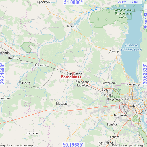
Borodianka GPS coordinates[2]
50° 38' 41.424" North, 29° 55' 12.36" East
| Map corner | latitude | longitude |
|---|---|---|
| Upper-left | 51.0886°, | 29.21698° |
| Center: | 50.64484°, | 29.9201° |
| Lower-right: | 50.19685°, | 30.62323° |
| Map W x H: | 99.2×99.2 km | = 61.6×61.6mi |
| max Lat: | 52.18903° ⇑7% North |
| Borodianka: | 50.64484° |
| min Lat: | ⇓93% South 44.39214° |
| min Long | Borodianka | max Long |
| 22.20555° | 29.9201° | 40.13222° |
| W 31.9%⇐ | ⇒68.1% E |
Elevation
Elevation of Borodianka is 139 m = 456 ft, and this is 16.8 m = 55 ft below average elevation for this country.
| Max E: |
886 m = 2907 ft | 49.1% |
| Avg. | 155.8 m = 511 ft | |
| Borodianka | 139 m = 456 ft | |
Min E: |
-3 m = -10 ft | 50.9% |
See also: Ukraine elevation on elevation.city.
Geographical zone
Borodianka is located in North temperate zone (between Tropic of Cancer and the Arctic Circle). Distance of this North polar circle is 1770 km =1099.8 mi to North.| Distance of | km | miles | from Borodianka |
|---|---|---|---|
| North Pole | 4375.9 | 2719.1 | to North |
| Arctic Circle | 1770 | 1099.8 | to North |
| Tropic Cancer | 3025.3 | 1879.8 | to South |
| Equator | 5631.2 | 3499.1 | to South |


Nearby cities:
15 places around Borodianka: (largest is in red/bold)
• Bila Krynytsya
31.7 km =19.7 mi,  268°
268°
• Bucha
23.5 km =14.6 mi,  118°
118°
• Dymer
31.2 km =19.4 mi,  59°
59°
• Horenka
30.7 km =19.1 mi,  108°
108°
• Horodok
32.9 km =20.4 mi,  260°
260°
• Hostomel
25.8 km =16 mi, 109°
• Irpin
27 km =16.8 mi, 120°
• Ivankiv
32.7 km =20.3 mi,  356°
356°
• Katyuzhanka
23.6 km =14.7 mi,  40°
40°
• Klavdiyevo-Tarasove
9.3 km =5.8 mi,  136°
136°
• Kodra
26.1 km =16.2 mi, 257°
• Makariv
21.5 km =13.4 mi,  200°
200°
• Piskivka
21.9 km =13.6 mi,  284°
284°
• Vorzel’
19.9 km =12.4 mi, 124°
• Yasnohorodka
32.9 km =20.4 mi,  167°
167°
Sources, notices
• [Note1] Compared only with cities in Ukraine existing in our database
• [Src1] Map data: © OpenStreetMap contributors (CC-BY-SA)
• [Src2] Other city data from geonames.org with taken over terms of usage.
• [Src3] Geographical zone / Annual Mean Temperature by Robert A. Rohde @ Wikipedia
