Ulaniv geodata
Ulaniv (Vinnyts'ka) is a populated place; located in Ukraine in Europe/Kiev (GMT+3) time zone. With population of 3,038 people, there are 933 cities with bigger population in this country. Compared to other cities in Ukraine, 77.9% of cities are located further ↓South; 75.4% of cities are located further →East and 84.4% of cities have lower elevation than Ulaniv. Note1


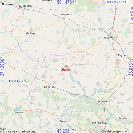
Ulaniv GPS coordinates[2]
49° 41' 42.432" North, 28° 7' 58.728" East
| Map corner | latitude | longitude |
|---|---|---|
| Upper-left | 50.14781°, | 27.42986° |
| Center: | 49.69512°, | 28.13298° |
| Lower-right: | 49.23817°, | 28.83611° |
| Map W x H: | 101.1×101.1 km | = 62.8×62.8mi |
| max Lat: | 52.18903° ⇑22.1% North |
| Ulaniv: | 49.69512° |
| min Lat: | ⇓77.9% South 44.39214° |
| min Long | Ulaniv | max Long |
| 22.20555° | 28.13298° | 40.13222° |
| W 24.6%⇐ | ⇒75.4% E |
Elevation
Elevation of Ulaniv is 269 m = 883 ft, and this is 113.2 m = 371 ft above average elevation for this country.
| Max E: |
886 m = 2907 ft | 15.6% |
| Ulaniv | 269 m 883 ft | |
| Avg. | 155.8 m = 511 ft | |
Min E: |
-3 m = -10 ft | 84.4% |
See also: Ukraine elevation on elevation.city.
Geographical zone
Ulaniv is located in North temperate zone (between Tropic of Cancer and the Arctic Circle). Distance of this North polar circle is 1875.6 km =1165.4 mi to North.| Distance of | km | miles | from Ulaniv |
|---|---|---|---|
| North Pole | 4481.5 | 2784.7 | to North |
| Arctic Circle | 1875.6 | 1165.4 | to North |
| Tropic Cancer | 2919.7 | 1814.2 | to South |
| Equator | 5525.6 | 3433.4 | to South |


Nearby cities:
15 places around Ulaniv: (largest is in red/bold)
• Berdychiv
40.6 km =25.2 mi,  56°
56°
• Chudniv
39.7 km =24.7 mi,  358°
358°
• Hryshkivtsi
43.1 km =26.8 mi,  51°
51°
• Kalynivka
39 km =24.2 mi,  133°
133°
• Khmilnyk
19.6 km =12.2 mi,  220°
220°
• Kozyatyn
50.4 km =31.3 mi,  87°
87°
• Letychiv
50.2 km =31.2 mi,  226°
226°
• Lityn
41.3 km =25.7 mi,  185°
185°
• Liubar
36.7 km =22.8 mi,  313°
313°
• Nova Pryluka
54.2 km =33.7 mi, 131°
• Pavlivka
36.7 km =22.8 mi,  140°
140°
• Romaniv
52.4 km =32.6 mi,  343°
343°
• Sobolivka
54.7 km =34 mi, 136°
• Stara Syniava
38.4 km =23.9 mi,  254°
254°
• Suslivtsi
45.1 km =28 mi, 230°
Sources, notices
• [Note1] Compared only with cities in Ukraine existing in our database
• [Src1] Map data: © OpenStreetMap contributors (CC-BY-SA)
• [Src2] Other city data from geonames.org with taken over terms of usage.
• [Src3] Geographical zone / Annual Mean Temperature by Robert A. Rohde @ Wikipedia
