Muromskoye geodata
Muromskoye (Republic of Crimea) is a seat of a third-order administrative division; located in Ukraine in Europe/Simferopol (GMT+3) time zone. With population of 755 people, there are 1506 cities with bigger population in this country. Compared to other cities in Ukraine, 88.6% of cities are located further ↑North; 78.4% of cities are located further ←West and 71.8% of cities have lower elevation than Muromskoye. Note1
Administrative division(s):
- Level 1: Republic of Crimea
- Level 2: Belogorskiy rayon
- Level 3: Muromskoye sel'skoye poselenye


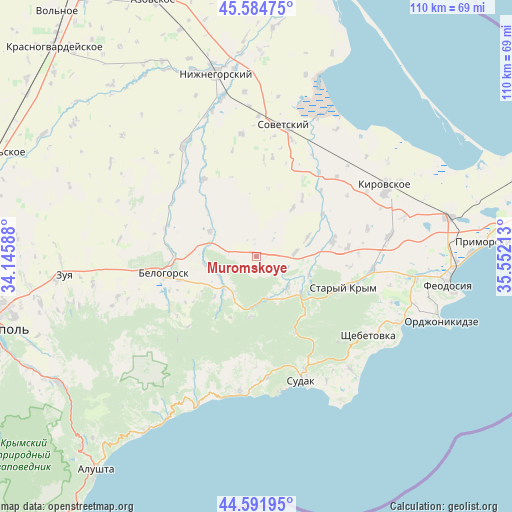
Muromskoye GPS coordinates[2]
45° 5' 25.836" North, 34° 50' 56.4" East
| Map corner | latitude | longitude |
|---|---|---|
| Upper-left | 45.58475°, | 34.14588° |
| Center: | 45.09051°, | 34.849° |
| Lower-right: | 44.59195°, | 35.55213° |
| Map W x H: | 110.4×110.4 km | = 68.6×68.6mi |
| max Lat: | 52.18903° ⇑88.6% North |
| Muromskoye: | 45.09051° |
| min Lat: | ⇓11.4% South 44.39214° |
| min Long | Muromskoye | max Long |
| 22.20555° | 34.849° | 40.13222° |
| W 78.4%⇐ | ⇒21.6% E |
Elevation
Elevation of Muromskoye is 213 m = 699 ft, and this is 57.2 m = 188 ft above average elevation for this country.
| Max E: |
886 m = 2907 ft | 28.2% |
| Muromskoye | 213 m 699 ft | |
| Avg. | 155.8 m = 511 ft | |
Min E: |
-3 m = -10 ft | 71.8% |
See also: Ukraine elevation on elevation.city.
Geographical zone
Muromskoye is located in North temperate zone (between Tropic of Cancer and the Arctic Circle). Distance of this North polar circle is 2387.6 km =1483.6 mi to North.| Distance of | km | miles | from Muromskoye |
|---|---|---|---|
| North Pole | 4993.5 | 3102.8 | to North |
| Arctic Circle | 2387.6 | 1483.6 | to North |
| Tropic Cancer | 2407.7 | 1496.1 | to South |
| Equator | 5013.6 | 3115.3 | to South |


Nearby cities:
15 places around Muromskoye: (largest is in red/bold)
• Bogatoye
9.4 km =5.8 mi,  223°
223°
• Grushevka
12.3 km =7.6 mi,  127°
127°
• Kholodovka
12.1 km =7.5 mi,  110°
110°
• Krasnogvardeyskoye
13.1 km =8.1 mi,  37°
37°
• Kurskoye
9.7 km =6 mi, 134°
• Lechebnoye
9 km =5.6 mi,  241°
241°
• L’govskoye
8.6 km =5.3 mi,  84°
84°
• Michurinskoye
11.3 km =7 mi,  260°
260°
• Pavlovka
14.3 km =8.9 mi,  313°
313°
• Perevalovka
16.4 km =10.2 mi,  140°
140°
• Privetnoye
16.8 km =10.4 mi, 78°
• Pushkino
16.1 km =10 mi, 38°
• Vasilyevka
11.3 km =7 mi,  298°
298°
• Zemlyanichnoye
12.9 km =8 mi,  184°
184°
• Zolotoye Pole
11.9 km =7.4 mi,  69°
69°
Sources, notices
• [Note1] Compared only with cities in Ukraine existing in our database
• [Src1] Map data: © OpenStreetMap contributors (CC-BY-SA)
• [Src2] Other city data from geonames.org with taken over terms of usage.
• [Src3] Geographical zone / Annual Mean Temperature by Robert A. Rohde @ Wikipedia
