Hornostayivka geodata
Hornostayivka (Kherson) is a seat of a second-order administrative division; located in Ukraine in Europe/Kiev (GMT+3) time zone. With population of 6,762 people, there are 525 cities with bigger population in this country. Compared to other cities in Ukraine, 63.8% of cities are located further ↑North; 56% of cities are located further ←West and 75.2% of cities have higher elevation than Hornostayivka. Note1


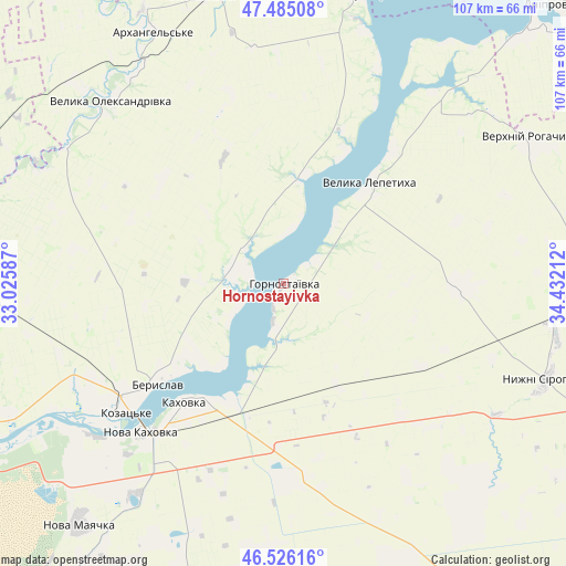
Hornostayivka GPS coordinates[2]
47° 0' 27.972" North, 33° 43' 44.364" East
| Map corner | latitude | longitude |
|---|---|---|
| Upper-left | 47.48508°, | 33.02587° |
| Center: | 47.00777°, | 33.72899° |
| Lower-right: | 46.52616°, | 34.43212° |
| Map W x H: | 106.6×106.6 km | = 66.2×66.2mi |
| max Lat: | 52.18903° ⇑63.8% North |
| Hornostayivka: | 47.00777° |
| min Lat: | ⇓36.2% South 44.39214° |
| min Long | Hornostayivka | max Long |
| 22.20555° | 33.72899° | 40.13222° |
| W 56%⇐ | ⇒44% E |
Elevation
Elevation of Hornostayivka is 59 m = 194 ft, and this is 96.8 m = 318 ft below average elevation for this country.
| Max E: |
886 m = 2907 ft | 75.2% |
| Avg. | 155.8 m = 511 ft | |
| Hornostayivka | 59 m = 194 ft | |
Min E: |
-3 m = -10 ft | 24.8% |
See also: Ukraine elevation on elevation.city.
Geographical zone
Hornostayivka is located in North temperate zone (between Tropic of Cancer and the Arctic Circle). Distance of this North polar circle is 2174.4 km =1351.1 mi to North.| Distance of | km | miles | from Hornostayivka |
|---|---|---|---|
| North Pole | 4780.3 | 2970.3 | to North |
| Arctic Circle | 2174.4 | 1351.1 | to North |
| Tropic Cancer | 2620.9 | 1628.6 | to South |
| Equator | 5226.8 | 3247.8 | to South |


Nearby cities:
15 places around Hornostayivka: (largest is in red/bold)
• Beryslav
29.4 km =18.3 mi,  231°
231°
• Chornyanka
48.5 km =30.1 mi,  215°
215°
• Dnipryany
45.2 km =28.1 mi, 230°
• Dudchany
19.9 km =12.4 mi,  7°
7°
• Kakhovka
28.3 km =17.6 mi, 220°
• Kayiry
7.2 km =4.5 mi,  194°
194°
• Lyubymivka
25.1 km =15.6 mi,  209°
209°
• Malokakhovka
33 km =20.5 mi, 220°
• Nova Kakhovka
40.4 km =25.1 mi, 225°
• Novovorontsovka
56.6 km =35.2 mi, 14°
• Nyzhni Sirohozy
52.5 km =32.6 mi,  109°
109°
• Velyka Lepetykha
24.8 km =15.4 mi,  41°
41°
• Velyka Oleksandrivka
47.3 km =29.4 mi,  317°
317°
• Verkhniy Rohachyk
53.4 km =33.2 mi,  59°
59°
• Vysokopillya
55.9 km =34.7 mi,  344°
344°
Sources, notices
• [Note1] Compared only with cities in Ukraine existing in our database
• [Src1] Map data: © OpenStreetMap contributors (CC-BY-SA)
• [Src2] Other city data from geonames.org with taken over terms of usage.
• [Src3] Geographical zone / Annual Mean Temperature by Robert A. Rohde @ Wikipedia
