Vysokopillya geodata
Vysokopillya (Kherson) is a seat of a second-order administrative division; located in Ukraine in Europe/Kiev (GMT+3) time zone. With population of 4,542 people, there are 693 cities with bigger population in this country. Compared to other cities in Ukraine, 60.7% of cities are located further ↑North; 52.2% of cities are located further ←West and 66.1% of cities have higher elevation than Vysokopillya. Note1


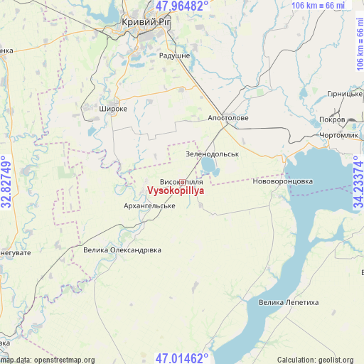
Vysokopillya GPS coordinates[2]
47° 29' 30.732" North, 33° 31' 50.196" East
| Map corner | latitude | longitude |
|---|---|---|
| Upper-left | 47.96482°, | 32.82749° |
| Center: | 47.49187°, | 33.53061° |
| Lower-right: | 47.01462°, | 34.23374° |
| Map W x H: | 105.7×105.7 km | = 65.7×65.7mi |
| max Lat: | 52.18903° ⇑60.7% North |
| Vysokopillya: | 47.49187° |
| min Lat: | ⇓39.3% South 44.39214° |
| min Long | Vysokopillya | max Long |
| 22.20555° | 33.53061° | 40.13222° |
| W 52.2%⇐ | ⇒47.8% E |
Elevation
Elevation of Vysokopillya is 86 m = 282 ft, and this is 69.8 m = 229 ft below average elevation for this country.
| Max E: |
886 m = 2907 ft | 66.1% |
| Avg. | 155.8 m = 511 ft | |
| Vysokopillya | 86 m = 282 ft | |
Min E: |
-3 m = -10 ft | 33.9% |
See also: Ukraine elevation on elevation.city.
Geographical zone
Vysokopillya is located in North temperate zone (between Tropic of Cancer and the Arctic Circle). Distance of this North polar circle is 2120.6 km =1317.7 mi to North.| Distance of | km | miles | from Vysokopillya |
|---|---|---|---|
| North Pole | 4726.5 | 2936.9 | to North |
| Arctic Circle | 2120.6 | 1317.7 | to North |
| Tropic Cancer | 2674.7 | 1662 | to South |
| Equator | 5280.6 | 3281.2 | to South |


Nearby cities:
15 places around Vysokopillya: (largest is in red/bold)
• Apostolove
23.2 km =14.4 mi,  36°
36°
• Bereznehuvate
55.2 km =34.3 mi,  248°
248°
• Chortomlyk
48.1 km =29.9 mi,  72°
72°
• Dudchany
38.3 km =23.8 mi,  152°
152°
• Hornostayivka
55.9 km =34.7 mi,  164°
164°
• Kayiry
62.2 km =38.6 mi,  167°
167°
• Kryvyi Rih
47.8 km =29.7 mi,  346°
346°
• Lozuvatka
65.5 km =40.7 mi,  343°
343°
• Nikopol
65.6 km =40.8 mi,  82°
82°
• Novovorontsovka
29.1 km =18.1 mi,  88°
88°
• Ordzhonikidze
44.2 km =27.5 mi,  63°
63°
• Sholokhove
43.8 km =27.2 mi, 59°
• Shyroke
30.2 km =18.8 mi,  317°
317°
• Velyka Lepetykha
47 km =29.2 mi,  138°
138°
• Velyka Oleksandrivka
25.7 km =16 mi,  221°
221°
Sources, notices
• [Note1] Compared only with cities in Ukraine existing in our database
• [Src1] Map data: © OpenStreetMap contributors (CC-BY-SA)
• [Src2] Other city data from geonames.org with taken over terms of usage.
• [Src3] Geographical zone / Annual Mean Temperature by Robert A. Rohde @ Wikipedia
