Bilky geodata
Bilky (Transcarpathia) is a populated place; located in Ukraine in Europe/Uzhgorod (GMT+3) time zone. With population of 7,778 people, there are 461 cities with bigger population in this country. Compared to other cities in Ukraine, 50.3% of cities are located further ↓South; 97.8% of cities are located further →East and 53.5% of cities have lower elevation than Bilky. Note1


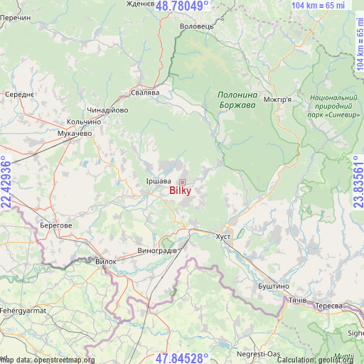
Bilky GPS coordinates[2]
48° 18' 54.108" North, 23° 7' 56.928" East
| Map corner | latitude | longitude |
|---|---|---|
| Upper-left | 48.78049°, | 22.42936° |
| Center: | 48.31503°, | 23.13248° |
| Lower-right: | 47.84528°, | 23.83561° |
| Map W x H: | 104×104 km | = 64.6×64.6mi |
| max Lat: | 52.18903° ⇑49.7% North |
| Bilky: | 48.31503° |
| min Lat: | ⇓50.3% South 44.39214° |
| min Long | Bilky | max Long |
| 22.20555° | 23.13248° | 40.13222° |
| W 2.2%⇐ | ⇒97.8% E |
Elevation
Elevation of Bilky is 147 m = 482 ft, and this is 8.8 m = 29 ft below average elevation for this country.
| Max E: |
886 m = 2907 ft | 46.5% |
| Avg. | 155.8 m = 511 ft | |
| Bilky | 147 m = 482 ft | |
Min E: |
-3 m = -10 ft | 53.5% |
See also: Ukraine elevation on elevation.city.
Geographical zone
Bilky is located in North temperate zone (between Tropic of Cancer and the Arctic Circle). Distance of this North polar circle is 2029 km =1260.8 mi to North.| Distance of | km | miles | from Bilky |
|---|---|---|---|
| North Pole | 4634.9 | 2880 | to North |
| Arctic Circle | 2029 | 1260.8 | to North |
| Tropic Cancer | 2766.2 | 1718.8 | to South |
| Equator | 5372.1 | 3338.1 | to South |


Nearby cities:
15 places around Bilky: (largest is in red/bold)
• Bereznyky
23.1 km =14.4 mi,  16°
16°
• Dovhe
12.2 km =7.6 mi,  62°
62°
• Horinchovo
22.9 km =14.2 mi,  102°
102°
• Irshava
7 km =4.3 mi,  271°
271°
• Iza
18.3 km =11.4 mi,  127°
127°
• Khust
19.5 km =12.1 mi,  140°
140°
• Korolevo
18.1 km =11.2 mi,  179°
179°
• Kryva
17.6 km =10.9 mi,  154°
154°
• Kushnytsya
16.7 km =10.4 mi,  33°
33°
• Lypcha
19.5 km =12.1 mi,  107°
107°
• Lysychovo
23.3 km =14.5 mi, 29°
• Oleshnyk
21 km =13 mi,  216°
216°
• Pidvynohradiv
22.9 km =14.2 mi,  211°
211°
• Rokosovo
12.1 km =7.5 mi,  164°
164°
• Vynohradiv
20.8 km =12.9 mi,  202°
202°
Sources, notices
• [Note1] Compared only with cities in Ukraine existing in our database
• [Src1] Map data: © OpenStreetMap contributors (CC-BY-SA)
• [Src2] Other city data from geonames.org with taken over terms of usage.
• [Src3] Geographical zone / Annual Mean Temperature by Robert A. Rohde @ Wikipedia
