Kushnytsya geodata
Kushnytsya (Transcarpathia) is a populated place; located in Ukraine in Europe/Uzhgorod (GMT+3) time zone. With population of 4,508 people, there are 701 cities with bigger population in this country. Compared to other cities in Ukraine, 53.7% of cities are located further ↓South; 97.1% of cities are located further →East and 75% of cities have lower elevation than Kushnytsya. Note1


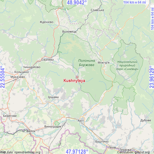
Kushnytsya GPS coordinates[2]
48° 26' 23.568" North, 23° 15' 29.376" East
| Map corner | latitude | longitude |
|---|---|---|
| Upper-left | 48.9042°, | 22.55504° |
| Center: | 48.43988°, | 23.25816° |
| Lower-right: | 47.97128°, | 23.96129° |
| Map W x H: | 103.7×103.7 km | = 64.4×64.4mi |
| max Lat: | 52.18903° ⇑46.3% North |
| Kushnytsya: | 48.43988° |
| min Lat: | ⇓53.7% South 44.39214° |
| min Long | Kushnytsya | max Long |
| 22.20555° | 23.25816° | 40.13222° |
| W 2.9%⇐ | ⇒97.1% E |
Elevation
Elevation of Kushnytsya is 227 m = 745 ft, and this is 71.2 m = 234 ft above average elevation for this country.
| Max E: |
886 m = 2907 ft | 25% |
| Kushnytsya | 227 m 745 ft | |
| Avg. | 155.8 m = 511 ft | |
Min E: |
-3 m = -10 ft | 75% |
See also: Ukraine elevation on elevation.city.
Geographical zone
Kushnytsya is located in North temperate zone (between Tropic of Cancer and the Arctic Circle). Distance of this North polar circle is 2015.2 km =1252.2 mi to North.| Distance of | km | miles | from Kushnytsya |
|---|---|---|---|
| North Pole | 4621.1 | 2871.4 | to North |
| Arctic Circle | 2015.2 | 1252.2 | to North |
| Tropic Cancer | 2780.1 | 1727.5 | to South |
| Equator | 5386 | 3346.7 | to South |


Nearby cities:
15 places around Kushnytsya: (largest is in red/bold)
• Bereznyky
8.7 km =5.4 mi,  341°
341°
• Berezovo
21.6 km =13.4 mi,  132°
132°
• Bilky
16.7 km =10.4 mi,  213°
213°
• Dovhe
8.4 km =5.2 mi,  169°
169°
• Horinchovo
22.9 km =14.2 mi,  145°
145°
• Irshava
21.2 km =13.2 mi,  229°
229°
• Iza
25.5 km =15.8 mi, 168°
• Lypcha
21.9 km =13.6 mi,  155°
155°
• Lysychovo
6.7 km =4.2 mi,  20°
20°
• Mizhhirya
20.5 km =12.7 mi,  62°
62°
• Nelipyno
21.5 km =13.4 mi,  308°
308°
• Pylypets
24.4 km =15.2 mi,  4°
4°
• Rokosovo
26.2 km =16.3 mi,  193°
193°
• Svalyava
22.8 km =14.2 mi,  301°
301°
• Synevyr
27.6 km =17.1 mi,  78°
78°
Sources, notices
• [Note1] Compared only with cities in Ukraine existing in our database
• [Src1] Map data: © OpenStreetMap contributors (CC-BY-SA)
• [Src2] Other city data from geonames.org with taken over terms of usage.
• [Src3] Geographical zone / Annual Mean Temperature by Robert A. Rohde @ Wikipedia
