Yamnytsya geodata
Yamnytsya (Ivano-Frankivsk) is a populated place; located in Ukraine in Europe/Kiev (GMT+3) time zone. With population of 3,223 people, there are 882 cities with bigger population in this country. Compared to other cities in Ukraine, 66% of cities are located further ↓South; 87.9% of cities are located further →East and 76.3% of cities have lower elevation than Yamnytsya. Note1


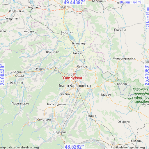
Yamnytsya GPS coordinates[2]
48° 59' 22.992" North, 24° 42' 27" East
| Map corner | latitude | longitude |
|---|---|---|
| Upper-left | 49.44897°, | 24.00438° |
| Center: | 48.98972°, | 24.7075° |
| Lower-right: | 48.5262°, | 25.41063° |
| Map W x H: | 102.6×102.6 km | = 63.8×63.8mi |
| max Lat: | 52.18903° ⇑34% North |
| Yamnytsya: | 48.98972° |
| min Lat: | ⇓66% South 44.39214° |
| min Long | Yamnytsya | max Long |
| 22.20555° | 24.7075° | 40.13222° |
| W 12.1%⇐ | ⇒87.9% E |
Elevation
Elevation of Yamnytsya is 231 m = 758 ft, and this is 75.2 m = 247 ft above average elevation for this country.
| Max E: |
886 m = 2907 ft | 23.7% |
| Yamnytsya | 231 m 758 ft | |
| Avg. | 155.8 m = 511 ft | |
Min E: |
-3 m = -10 ft | 76.3% |
See also: Ukraine elevation on elevation.city.
Geographical zone
Yamnytsya is located in North temperate zone (between Tropic of Cancer and the Arctic Circle). Distance of this North polar circle is 1954 km =1214.2 mi to North.| Distance of | km | miles | from Yamnytsya |
|---|---|---|---|
| North Pole | 4559.9 | 2833.4 | to North |
| Arctic Circle | 1954 | 1214.2 | to North |
| Tropic Cancer | 2841.2 | 1765.4 | to South |
| Equator | 5447.1 | 3384.7 | to South |


Nearby cities:
15 places around Yamnytsya: (largest is in red/bold)
• Bilshivtsi
21.7 km =13.5 mi,  8°
8°
• Bohorodchany
23.8 km =14.8 mi,  211°
211°
• Cherniyiv
14.8 km =9.2 mi,  178°
178°
• Chornoliztsi
22.4 km =13.9 mi,  142°
142°
• Halych
14.7 km =9.1 mi, 5°
• Ivano-Frankivsk
7.6 km =4.7 mi, 178°
• Kalush
24.5 km =15.2 mi,  275°
275°
• Novytsya
27.3 km =17 mi,  263°
263°
• Radcha
16 km =9.9 mi,  193°
193°
• Stari Bohorodchany
21.9 km =13.6 mi,  217°
217°
• Tlumach
25.7 km =16 mi,  122°
122°
• Tysmenychany
24.4 km =15.2 mi, 187°
• Tysmenytsya
14 km =8.7 mi,  134°
134°
• Uhryniv
4 km =2.5 mi,  195°
195°
• Zahvizdya
8.9 km =5.5 mi, 206°
Sources, notices
• [Note1] Compared only with cities in Ukraine existing in our database
• [Src1] Map data: © OpenStreetMap contributors (CC-BY-SA)
• [Src2] Other city data from geonames.org with taken over terms of usage.
• [Src3] Geographical zone / Annual Mean Temperature by Robert A. Rohde @ Wikipedia
