Ivano-Frankivsk geodata
Ivano-Frankivsk is a seat of a first-order administrative division; located in Ukraine in Europe/Kiev (GMT+3) time zone. With population of 204,200 people, there are 30 cities with bigger population in this country. Compared to other cities in Ukraine, 64.6% of cities are located further ↓South; 87.8% of cities are located further →East and 82.2% of cities have lower elevation than Ivano-Frankivsk. Note1


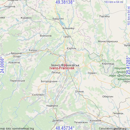
Ivano-Frankivsk GPS coordinates[2]
48° 55' 17.4" North, 24° 42' 34.992" East
| Map corner | latitude | longitude |
|---|---|---|
| Upper-left | 49.38138°, | 24.0066° |
| Center: | 48.9215°, | 24.70972° |
| Lower-right: | 48.45734°, | 25.41285° |
| Map W x H: | 102.7×102.7 km | = 63.8×63.8mi |
| max Lat: | 52.18903° ⇑35.4% North |
| Ivano-Frankivsk: | 48.9215° |
| min Lat: | ⇓64.6% South 44.39214° |
| min Long | Ivano-Frankivsk | max Long |
| 22.20555° | 24.70972° | 40.13222° |
| W 12.2%⇐ | ⇒87.8% E |
Elevation
Elevation of Ivano-Frankivsk is 259 m = 850 ft, and this is 103.2 m = 339 ft above average elevation for this country.
| Max E: |
886 m = 2907 ft | 17.8% |
| Ivano-Frankivsk | 259 m 850 ft | |
| Avg. | 155.8 m = 511 ft | |
Min E: |
-3 m = -10 ft | 82.2% |
See also: Ivano-Frankivsk elevation on elevation.city.
Geographical zone
Ivano-Frankivsk is located in North temperate zone (between Tropic of Cancer and the Arctic Circle). Distance of this North polar circle is 1961.6 km =1218.9 mi to North.| Distance of | km | miles | from Ivano-Frankivsk |
|---|---|---|---|
| North Pole | 4567.5 | 2838.1 | to North |
| Arctic Circle | 1961.6 | 1218.9 | to North |
| Tropic Cancer | 2833.6 | 1760.7 | to South |
| Equator | 5439.6 | 3380 | to South |


Nearby cities:
15 places around Ivano-Frankivsk: (largest is in red/bold)
• Bohorodchany
17.9 km =11.1 mi,  224°
224°
• Cherniyiv
7.2 km =4.5 mi,  177°
177°
• Chornoliztsi
17 km =10.6 mi,  126°
126°
• Halych
22.3 km =13.9 mi,  3°
3°
• Kalush
26.5 km =16.5 mi,  292°
292°
• Novytsya
27.7 km =17.2 mi,  279°
279°
• Otyniya
23.3 km =14.5 mi,  151°
151°
• Radcha
8.9 km =5.5 mi,  206°
206°
• Stari Bohorodchany
16.7 km =10.4 mi,  234°
234°
• Tlumach
22.4 km =13.9 mi,  106°
106°
• Tysmenychany
17 km =10.6 mi,  190°
190°
• Tysmenytsya
10.1 km =6.3 mi,  102°
102°
• Uhryniv
3.9 km =2.4 mi,  341°
341°
• Yamnytsya
7.6 km =4.7 mi,  358°
358°
• Zahvizdya
4.2 km =2.6 mi,  265°
265°
Sources, notices
• [Note1] Compared only with cities in Ukraine existing in our database
• [Src1] Map data: © OpenStreetMap contributors (CC-BY-SA)
• [Src2] Other city data from geonames.org with taken over terms of usage.
• [Src3] Geographical zone / Annual Mean Temperature by Robert A. Rohde @ Wikipedia
