Chernopolye geodata
Chernopolye (Republic of Crimea) is a seat of a third-order administrative division; located in Ukraine in Europe/Simferopol (GMT+3) time zone. With population of 1,251 people, there are 1281 cities with bigger population in this country. Compared to other cities in Ukraine, 89.9% of cities are located further ↑North; 75.4% of cities are located further ←West and 75% of cities have lower elevation than Chernopolye. Note1
Administrative division(s):
- Level 1: Republic of Crimea
- Level 2: Belogorskiy rayon
- Level 3: Chernopol'skoye sel'skoye poselenye


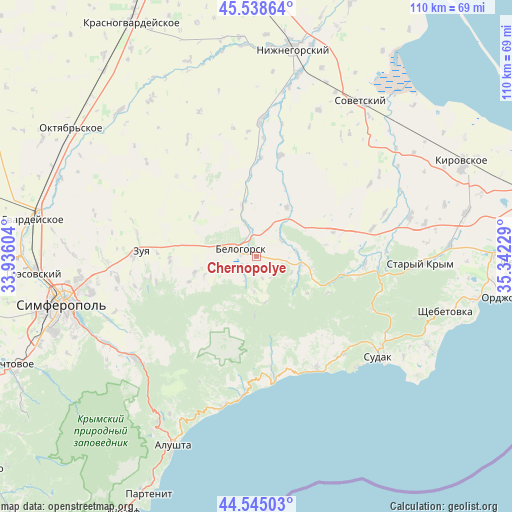
Chernopolye GPS coordinates[2]
45° 2' 38.364" North, 34° 38' 20.976" East
| Map corner | latitude | longitude |
|---|---|---|
| Upper-left | 45.53864°, | 33.93604° |
| Center: | 45.04399°, | 34.63916° |
| Lower-right: | 44.54503°, | 35.34229° |
| Map W x H: | 110.5×110.5 km | = 68.7×68.7mi |
| max Lat: | 52.18903° ⇑89.9% North |
| Chernopolye: | 45.04399° |
| min Lat: | ⇓10.1% South 44.39214° |
| min Long | Chernopolye | max Long |
| 22.20555° | 34.63916° | 40.13222° |
| W 75.4%⇐ | ⇒24.6% E |
Elevation
Elevation of Chernopolye is 227 m = 745 ft, and this is 71.2 m = 234 ft above average elevation for this country.
| Max E: |
886 m = 2907 ft | 25% |
| Chernopolye | 227 m 745 ft | |
| Avg. | 155.8 m = 511 ft | |
Min E: |
-3 m = -10 ft | 75% |
See also: Ukraine elevation on elevation.city.
Geographical zone
Chernopolye is located in North temperate zone (between Tropic of Cancer and the Arctic Circle). Distance of this North polar circle is 2392.8 km =1486.8 mi to North.| Distance of | km | miles | from Chernopolye |
|---|---|---|---|
| North Pole | 4998.6 | 3106 | to North |
| Arctic Circle | 2392.8 | 1486.8 | to North |
| Tropic Cancer | 2402.5 | 1492.8 | to South |
| Equator | 5008.4 | 3112.1 | to South |


Nearby cities:
15 places around Chernopolye: (largest is in red/bold)
• Aleksandrovka
8.9 km =5.5 mi,  256°
256°
• Balki
15.5 km =9.6 mi,  248°
248°
• Belaya Skala
5.6 km =3.5 mi,  346°
346°
• Bilohirsk
3.2 km =2 mi,  291°
291°
• Bogatoye
10.2 km =6.3 mi,  99°
99°
• Golovanovka
7.7 km =4.8 mi,  184°
184°
• Krinichnoye
3.1 km =1.9 mi,  224°
224°
• Lechebnoye
8.6 km =5.3 mi,  84°
84°
• Michurinskoye
6.3 km =3.9 mi,  57°
57°
• Novoklyonovo
12 km =7.5 mi, 249°
• Pavlovka
16.1 km =10 mi,  21°
21°
• Rusakovka
15.7 km =9.8 mi,  304°
304°
• Vasilyevka
12.5 km =7.8 mi,  31°
31°
• Vishennoye
11.7 km =7.3 mi,  343°
343°
• Zelenogorskoye
13.9 km =8.6 mi, 255°
Sources, notices
• [Note1] Compared only with cities in Ukraine existing in our database
• [Src1] Map data: © OpenStreetMap contributors (CC-BY-SA)
• [Src2] Other city data from geonames.org with taken over terms of usage.
• [Src3] Geographical zone / Annual Mean Temperature by Robert A. Rohde @ Wikipedia
