Michurinskoye geodata
Michurinskoye (Republic of Crimea) is a seat of a third-order administrative division; located in Ukraine in Europe/Simferopol (GMT+3) time zone. With population of 723 people, there are 1523 cities with bigger population in this country. Compared to other cities in Ukraine, 89% of cities are located further ↑North; 76.3% of cities are located further ←West and 76.3% of cities have lower elevation than Michurinskoye. Note1
Administrative division(s):
- Level 1: Republic of Crimea
- Level 2: Belogorskiy rayon
- Level 3: Michurinskoye sel'skoye poselenye


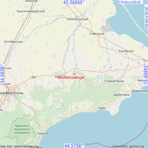
Michurinskoye GPS coordinates[2]
45° 4' 27.48" North, 34° 42' 24.192" East
| Map corner | latitude | longitude |
|---|---|---|
| Upper-left | 45.56868°, | 34.0036° |
| Center: | 45.0743°, | 34.70672° |
| Lower-right: | 44.5756°, | 35.40985° |
| Map W x H: | 110.4×110.4 km | = 68.6×68.6mi |
| max Lat: | 52.18903° ⇑89% North |
| Michurinskoye: | 45.0743° |
| min Lat: | ⇓11% South 44.39214° |
| min Long | Michurinskoye | max Long |
| 22.20555° | 34.70672° | 40.13222° |
| W 76.3%⇐ | ⇒23.7% E |
Elevation
Elevation of Michurinskoye is 231 m = 758 ft, and this is 75.2 m = 247 ft above average elevation for this country.
| Max E: |
886 m = 2907 ft | 23.7% |
| Michurinskoye | 231 m 758 ft | |
| Avg. | 155.8 m = 511 ft | |
Min E: |
-3 m = -10 ft | 76.3% |
See also: Ukraine elevation on elevation.city.
Geographical zone
Michurinskoye is located in North temperate zone (between Tropic of Cancer and the Arctic Circle). Distance of this North polar circle is 2389.4 km =1484.7 mi to North.| Distance of | km | miles | from Michurinskoye |
|---|---|---|---|
| North Pole | 4995.3 | 3103.9 | to North |
| Arctic Circle | 2389.4 | 1484.7 | to North |
| Tropic Cancer | 2405.9 | 1495 | to South |
| Equator | 5011.8 | 3114.2 | to South |


Nearby cities:
15 places around Michurinskoye: (largest is in red/bold)
• Aleksandrovka
15 km =9.3 mi,  248°
248°
• Belaya Skala
7 km =4.3 mi,  287°
287°
• Bilohirsk
8.5 km =5.3 mi,  255°
255°
• Bogatoye
6.9 km =4.3 mi,  136°
136°
• Chernopolye
6.3 km =3.9 mi,  237°
237°
• Golovanovka
12.5 km =7.8 mi,  208°
208°
• Krinichnoye
9.3 km =5.8 mi,  233°
233°
• Lechebnoye
4.1 km =2.5 mi,  127°
127°
• Muromskoye
11.3 km =7 mi,  80°
80°
• Novoklyonovo
18.2 km =11.3 mi, 245°
• Pavlovka
11.6 km =7.2 mi,  3°
3°
• Prudy
18.3 km =11.4 mi,  358°
358°
• Vasilyevka
7.3 km =4.5 mi,  9°
9°
• Vishennoye
11.7 km =7.3 mi,  312°
312°
• Zemlyanichnoye
15 km =9.3 mi, 137°
Sources, notices
• [Note1] Compared only with cities in Ukraine existing in our database
• [Src1] Map data: © OpenStreetMap contributors (CC-BY-SA)
• [Src2] Other city data from geonames.org with taken over terms of usage.
• [Src3] Geographical zone / Annual Mean Temperature by Robert A. Rohde @ Wikipedia
