Alekseyevka geodata
Alekseyevka (Republic of Crimea) is a seat of a third-order administrative division; located in Ukraine in Europe/Simferopol (GMT+3) time zone. With population of 913 people, there are 1425 cities with bigger population in this country. Compared to other cities in Ukraine, 75.6% of cities are located further ↑North; 54.2% of cities are located further ←West and 72.2% of cities have higher elevation than Alekseyevka. Note1
Administrative division(s):
- Level 1: Republic of Crimea
- Level 2: Pervomayskiy rayon
- Level 3: Alekseyevskoye sel'skoye poselenye


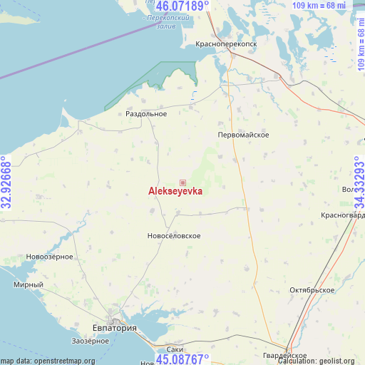
Alekseyevka GPS coordinates[2]
45° 34' 54.984" North, 33° 37' 47.28" East
| Map corner | latitude | longitude |
|---|---|---|
| Upper-left | 46.07189°, | 32.92668° |
| Center: | 45.58194°, | 33.6298° |
| Lower-right: | 45.08767°, | 34.33293° |
| Map W x H: | 109.4×109.4 km | = 68×68mi |
| max Lat: | 52.18903° ⇑75.6% North |
| Alekseyevka: | 45.58194° |
| min Lat: | ⇓24.4% South 44.39214° |
| min Long | Alekseyevka | max Long |
| 22.20555° | 33.6298° | 40.13222° |
| W 54.2%⇐ | ⇒45.8% E |
Elevation
Elevation of Alekseyevka is 69 m = 226 ft, and this is 86.8 m = 285 ft below average elevation for this country.
| Max E: |
886 m = 2907 ft | 72.2% |
| Avg. | 155.8 m = 511 ft | |
| Alekseyevka | 69 m = 226 ft | |
Min E: |
-3 m = -10 ft | 27.8% |
See also: Ukraine elevation on elevation.city.
Geographical zone
Alekseyevka is located in North temperate zone (between Tropic of Cancer and the Arctic Circle). Distance of this North polar circle is 2332.9 km =1449.6 mi to North.| Distance of | km | miles | from Alekseyevka |
|---|---|---|---|
| North Pole | 4938.8 | 3068.8 | to North |
| Arctic Circle | 2332.9 | 1449.6 | to North |
| Tropic Cancer | 2462.3 | 1530 | to South |
| Equator | 5068.2 | 3149.2 | to South |


Nearby cities:
15 places around Alekseyevka: (largest is in red/bold)
• Berezovka
22.3 km =13.9 mi,  267°
267°
• Grishino
17 km =10.6 mi,  66°
66°
• Kalinino
21.2 km =13.2 mi,  32°
32°
• Kormovoye
9.2 km =5.7 mi,  188°
188°
• Kovyl’noye
14.4 km =8.9 mi,  326°
326°
• Novoselovskoye
15.7 km =9.8 mi, 189°
• Orlovka
22.1 km =13.7 mi,  295°
295°
• Sary-Bash
12.3 km =7.6 mi,  95°
95°
• Senokosnoye
19 km =11.8 mi, 332°
• Serebryanka
12.2 km =7.6 mi, 301°
• Stepnoye
13.7 km =8.5 mi,  55°
55°
• Susanino
10.7 km =6.6 mi,  149°
149°
• Vinogradovo
21.1 km =13.1 mi,  176°
176°
• Voykovo
20.6 km =12.8 mi,  112°
112°
• Zimino
12.2 km =7.6 mi,  227°
227°
Sources, notices
• [Note1] Compared only with cities in Ukraine existing in our database
• [Src1] Map data: © OpenStreetMap contributors (CC-BY-SA)
• [Src2] Other city data from geonames.org with taken over terms of usage.
• [Src3] Geographical zone / Annual Mean Temperature by Robert A. Rohde @ Wikipedia
