Buyende geodata
Buyende (Eastern Region) is a seat of a second-order administrative division; located in Uganda in Africa/Kampala (GMT+3) time zone. In our database, there are 80 cities with bigger population. Compared to other cities in Uganda, 63% of cities are located further ↓South; 66.4% of cities are located further ←West and 89% of cities have higher elevation than Buyende. Note1
Administrative division(s):
- Level 1: Eastern Region
- Level 2: Buyende District
- Level 3: Budiope
- Level 4: Buyende Town Council


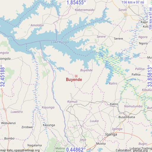
Buyende GPS coordinates[2]
1° 9' 6.012" North, 33° 9' 18" East
| Map corner | latitude | longitude |
|---|---|---|
| Upper-left | 1.85455°, | 32.45188° |
| Center: | 1.15167°, | 33.155° |
| Lower-right: | 0.44862°, | 33.85813° |
| Map W x H: | 156.3×156.3 km | = 97.1×97.1mi |
| max Lat: | 3.66088° ⇑37% North |
| Buyende: | 1.15167° |
| min Lat: | ⇓63% South -1.28538° |
| min Long | Buyende | max Long |
| 29.65° | 33.155° | 34.95° |
| W 66.4%⇐ | ⇒33.6% E |
Elevation
Elevation of Buyende is 1046 m = 3432 ft, and this is 213 m = 699 ft below average elevation for this country.
| Max E: |
4129 m = 13547 ft | 89% |
| Avg. | 1259 m = 4131 ft | |
| Buyende | 1046 m = 3432 ft | |
Min E: |
622 m = 2041 ft | 11% |
See also: Uganda elevation on elevation.city.
Geographical zone
Buyende is located in North Torrid zone (between Equator and Tropic of Cancer). Distance of Equator is 128.1 km =79.6 mi to South.| Distance of | km | miles | from Buyende |
|---|---|---|---|
| North Pole | 9879 | 6138.5 | to North |
| Arctic Circle | 7273.1 | 4519.3 | to North |
| Tropic Cancer | 2477.9 | 1539.7 | to North |
| Equator | 128.1 | 79.6 | to South |


Nearby cities:
15 places around Buyende: (largest is in red/bold)
• Amolatar
62.4 km =38.8 mi,  325°
325°
• Bugembe
75.1 km =46.7 mi,  172°
172°
• Busembatia
66.7 km =41.4 mi,  128°
128°
• Buwenge
55.8 km =34.7 mi,  178°
178°
• Iganga
69.7 km =43.3 mi,  149°
149°
• Kaberamaido
65.3 km =40.6 mi,  0°
0°
• Kaliro
47.8 km =29.7 mi, 126°
• Kamuli
23.1 km =14.4 mi,  189°
189°
• Kayunga
58.1 km =36.1 mi,  210°
210°
• Kibuku
72.4 km =45 mi,  99°
99°
• Luuka Town
52.7 km =32.7 mi,  162°
162°
• Namutumba
68.7 km =42.7 mi,  120°
120°
• Ngora
75.8 km =47.1 mi,  65°
65°
• Pallisa
61.6 km =38.3 mi,  90°
90°
• Serere
50.6 km =31.4 mi,  41°
41°
Sources, notices
• [Note1] Compared only with cities in Uganda existing in our database
• [Src1] Map data: © OpenStreetMap contributors (CC-BY-SA)
• [Src2] Other city data from geonames.org with taken over terms of usage.
• [Src3] Geographical zone / Annual Mean Temperature by Robert A. Rohde @ Wikipedia
