Sembabule geodata
Sembabule (Central Region) is a seat of a second-order administrative division; located in Uganda in Africa/Kampala (GMT+3) time zone. With population of 4,320 people, there are 75 cities with bigger population in this country. Compared to other cities in Uganda, 79.5% of cities are located further ↑North; 67.1% of cities are located further →East and 62.3% of cities have lower elevation than Sembabule. Note1
Administrative division(s):
- Level 1: Central Region
- Level 2: Sembabule District
- Level 3: Mawogola County
- Level 4: Sembabule Town Council


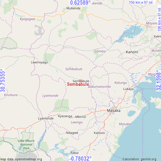
Sembabule GPS coordinates[2]
0° 4' 37.992" South, 31° 27' 24.012" East
| Map corner | latitude | longitude |
|---|---|---|
| Upper-left | 0.62589°, | 30.75355° |
| Center: | -0.07722°, | 31.45667° |
| Lower-right: | -0.78032°, | 32.1598° |
| Map W x H: | 156.4×156.4 km | = 97.2×97.2mi |
| max Lat: | 3.66088° ⇑79.5% North |
| Sembabule: | -0.07722° |
| min Lat: | ⇓20.5% South -1.28538° |
| min Long | Sembabule | max Long |
| 29.65° | 31.45667° | 34.95° |
| W 32.9%⇐ | ⇒67.1% E |
Elevation
Elevation of Sembabule is 1232 m = 4042 ft, and this is 27 m = 89 ft below average elevation for this country.
| Max E: |
4129 m = 13547 ft | 37.7% |
| Avg. | 1259 m = 4131 ft | |
| Sembabule | 1232 m = 4042 ft | |
Min E: |
622 m = 2041 ft | 62.3% |
See also: Uganda elevation on elevation.city.
Geographical zone
Sembabule is located in South Torrid zone (between Equator and Tropic of Capricorn). Distance of Equator is 8.6 km =5.3 mi to North.| Distance of | km | miles | from Sembabule |
|---|---|---|---|
| Equator | 8.6 | 5.3 | to North |
| Tropic Capricorn | 2597.3 | 1613.9 | to South |
| Antarctic Circle | 7392.6 | 4593.5 | to South |
| South Pole | 9998.5 | 6212.8 | to South |


Nearby cities:
15 places around Sembabule: (largest is in red/bold)
• Bukomansimbi
18.7 km =11.6 mi,  118°
118°
• Byakabanda
74.2 km =46.1 mi,  184°
184°
• Gombe
76.8 km =47.7 mi,  66°
66°
• Kalungu
35.1 km =21.8 mi,  107°
107°
• Kanoni
55 km =34.2 mi,  59°
59°
• Kasaali
60.9 km =37.8 mi,  170°
170°
• Kiruhura
69.4 km =43.1 mi,  258°
258°
• Kyegegwa
79.3 km =49.3 mi,  324°
324°
• Kyotera
60.2 km =37.4 mi, 173°
• Lwengo
38.1 km =23.7 mi,  188°
188°
• Lyantonde
49.2 km =30.6 mi,  222°
222°
• Masaka
42 km =26.1 mi,  132°
132°
• Mityana
83.6 km =51.9 mi,  48°
48°
• Mubende
71 km =44.1 mi,  354°
354°
• Rakai
71.5 km =44.4 mi, 177°
Sources, notices
• [Note1] Compared only with cities in Uganda existing in our database
• [Src1] Map data: © OpenStreetMap contributors (CC-BY-SA)
• [Src2] Other city data from geonames.org with taken over terms of usage.
• [Src3] Geographical zone / Annual Mean Temperature by Robert A. Rohde @ Wikipedia
