Byakabanda geodata
Byakabanda (Central Region) is a populated place; located in Uganda in Africa/Kampala (GMT+3) time zone. With population of 7,608 people, there are 69 cities with bigger population in this country. Compared to other cities in Uganda, 93.8% of cities are located further ↑North; 69.2% of cities are located further →East and 64.4% of cities have lower elevation than Byakabanda. Note1
Administrative division(s):
- Level 1: Central Region
- Level 2: Rakai District
- Level 3: Kooki
- Level 4: Byakabanda


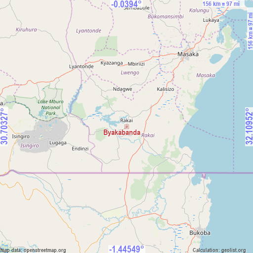
Byakabanda GPS coordinates[2]
0° 44' 33" South, 31° 24' 23.004" East
| Map corner | latitude | longitude |
|---|---|---|
| Upper-left | -0.0394°, | 30.70327° |
| Center: | -0.7425°, | 31.40639° |
| Lower-right: | -1.44549°, | 32.10952° |
| Map W x H: | 156.3×156.3 km | = 97.1×97.1mi |
| max Lat: | 3.66088° ⇑93.8% North |
| Byakabanda: | -0.7425° |
| min Lat: | ⇓6.2% South -1.28538° |
| min Long | Byakabanda | max Long |
| 29.65° | 31.40639° | 34.95° |
| W 30.8%⇐ | ⇒69.2% E |
Elevation
Elevation of Byakabanda is 1243 m = 4078 ft, and this is 16 m = 52 ft below average elevation for this country.
| Max E: |
4129 m = 13547 ft | 35.6% |
| Avg. | 1259 m = 4131 ft | |
| Byakabanda | 1243 m = 4078 ft | |
Min E: |
622 m = 2041 ft | 64.4% |
See also: Uganda elevation on elevation.city.
Geographical zone
Byakabanda is located in South Torrid zone (between Equator and Tropic of Capricorn). Distance of Equator is 82.6 km =51.3 mi to North.| Distance of | km | miles | from Byakabanda |
|---|---|---|---|
| Equator | 82.6 | 51.3 | to North |
| Tropic Capricorn | 2523.4 | 1568 | to South |
| Antarctic Circle | 7318.6 | 4547.6 | to South |
| South Pole | 9924.5 | 6166.8 | to South |


Nearby cities:
15 places around Byakabanda: (largest is in red/bold)
• Bukomansimbi
68.6 km =42.6 mi,  18°
18°
• Bwizibwera
88.1 km =54.7 mi,  280°
280°
• Isingiro
65.6 km =40.8 mi,  257°
257°
• Kalangala
103 km =64 mi,  62°
62°
• Kalungu
74.8 km =46.5 mi,  31°
31°
• Kasaali
21.2 km =13.2 mi,  48°
48°
• Kibingo
108.7 km =67.5 mi, 276°
• Kiruhura
87.1 km =54.1 mi,  314°
314°
• Kyotera
18.8 km =11.7 mi,  41°
41°
• Lwengo
36.3 km =22.6 mi,  0°
0°
• Lyantonde
46.8 km =29.1 mi,  323°
323°
• Masaka
58.2 km =36.2 mi, 38°
• Mbarara
85.6 km =53.2 mi, 280°
• Rakai
9 km =5.6 mi,  73°
73°
• Sembabule
74.2 km =46.1 mi, 4°
Sources, notices
• [Note1] Compared only with cities in Uganda existing in our database
• [Src1] Map data: © OpenStreetMap contributors (CC-BY-SA)
• [Src2] Other city data from geonames.org with taken over terms of usage.
• [Src3] Geographical zone / Annual Mean Temperature by Robert A. Rohde @ Wikipedia
